Charleston night lights from space
Night Light of Charleston (Missouri) from space (United States) Src. Average luminocity for 10x10km area is 12.3084% and for 50x50km: 5.2894%.
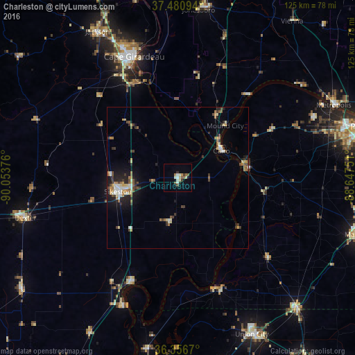
Analysis of Charleston night lights 2016
Square area 10x10 km:
 1.14%
1.14%90-99
2.76%80-89
1.3%70-79
1.3%60-69
1.79%50-59
2.44%40-49
0.32%30-39
1.95%20-29
0.81%10-19
1.14%0-9
85.06%Square area 50x50 km:
0.54%90-99
0.74%80-89
0.65%70-79
0.69%60-69
0.74%50-59
0.76%40-49
0.7%30-39
0.9%20-29
1.18%10-19
2.64%0-9
90.48%Clear (daylight) street map image can be seen on geolist.org.
Map coordinates:
37° 28' 51.4" North, 90° 3' 13.5" West
36° 55' 15.2" North, 89° 21' 2.3" West
36° 21' 24.1" North, 88° 38' 51" West
Some cities around Charleston sort by population:
• Cape Girardeau
45.3 km =28.1 mi,  340°
340°
• Paducah
69.1 km =42.9 mi,  74°
74°
• Sikeston
21.7 km =13.5 mi,  256°
256°
• Jackson
58.4 km =36.3 mi,  331°
331°
• Union City
61.1 km =38 mi,  154°
154°
• Mayfield
66.6 km =41.4 mi,  107°
107°
• Dexter
55.8 km =34.7 mi, 255°
• Metropolis
60.6 km =37.7 mi,  64°
64°
4380997 (p: 5,815)
Sources (retrieved 2019-11-25):
» Earth at Night: Flat Maps 2012, 2016