Cape Girardeau night lights from space
Night Light of Cape Girardeau (Missouri) from space (United States) Src. Average luminocity for 10x10km area is 51.3409% and for 50x50km: 8.0746%.

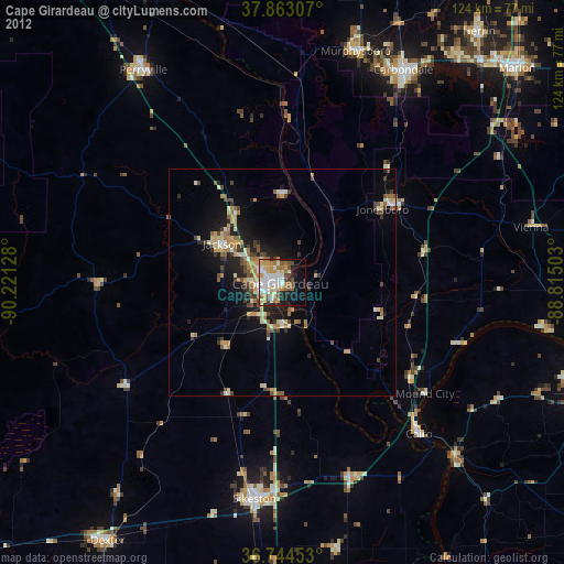
Analysis of Cape Girardeau night lights 2016
Square area 10x10 km:
 13.96%
90-99
11.36%80-89
6.33%70-79
5.19%60-69
6.82%50-59
6.17%40-49
4.55%30-39
5.52%20-29
9.25%10-19
15.58%0-9
15.26%Square area 50x50 km:
0.84%90-99
1.01%80-89
1.38%70-79
0.86%60-69
0.97%50-59
1.43%40-49
1.03%30-39
1.5%20-29
2.64%10-19
5.02%0-9
83.31%Clear (daylight) street map image can be seen on geolist.org.
Map coordinates:
37° 51' 47.1" North, 90° 13' 16.6" West
37° 18' 21.2" North, 89° 31' 5.3" West
36° 44' 40.3" North, 88° 48' 54.1" West
Some cities around Cape Girardeau sort by population:
• Carbondale
53.9 km =33.5 mi,  29°
29°
• Sikeston
48.1 km =29.9 mi,  187°
187°
• Jackson
15.6 km =9.7 mi,  302°
302°
• Perryville
55.5 km =34.5 mi,  326°
326°
• Dexter
68.8 km =42.8 mi,  214°
214°
• Murphysboro
53.5 km =33.2 mi,  17°
17°
• Carterville
63.7 km =39.6 mi,  37°
37°
• Charleston
45.3 km =28.1 mi,  160°
160°
4379966 (p: 39,462)
Sources (retrieved 2019-11-25):
» Earth at Night: Flat Maps 2012, 2016