Jackson night lights from space
Night Light of Jackson (Missouri) from space (United States) Src. Average luminocity for 10x10km area is 35.1672% and for 50x50km: 7.3109%.
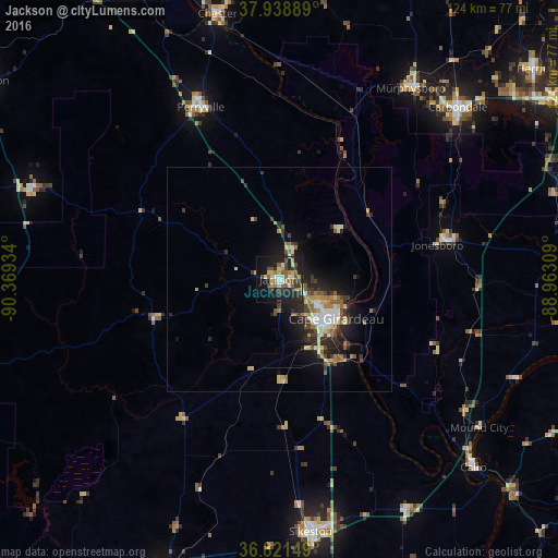
Analysis of Jackson night lights 2016
Square area 10x10 km:
 2.76%
2.76%90-99
4.22%80-89
5.68%70-79
4.87%60-69
4.55%50-59
7.47%40-49
5.68%30-39
7.31%20-29
12.99%10-19
27.6%0-9
16.88%Square area 50x50 km:
0.81%90-99
0.92%80-89
1.09%70-79
0.83%60-69
0.91%50-59
1.28%40-49
0.93%30-39
1.38%20-29
2.63%10-19
4.92%0-9
84.29%Clear (daylight) street map image can be seen on geolist.org.
Map coordinates:
37° 56' 20" North, 90° 22' 9.6" West
37° 22' 56.2" North, 89° 39' 58.4" West
36° 49' 17.4" North, 88° 57' 47.1" West
Some cities around Jackson sort by population:
• Cape Girardeau
15.6 km =9.7 mi,  122°
122°
• Carbondale
55.1 km =34.2 mi,  45°
45°
• Sikeston
56.6 km =35.2 mi,  172°
172°
• Chester
60.7 km =37.7 mi,  346°
346°
• Perryville
41.7 km =25.9 mi,  335°
335°
• Murphysboro
51.6 km =32.1 mi,  34°
34°
• Carterville
66.8 km =41.5 mi, 51°
• Charleston
58.4 km =36.3 mi,  151°
151°
4392163 (p: 14,869)
Sources (retrieved 2019-11-25):
» Earth at Night: Flat Maps 2012, 2016