Charles Village night lights from space
Night Light of Charles Village (Maryland) from space (United States) Src. Average luminocity for 10x10km area is 99.8486% and for 50x50km: 62.0459%.
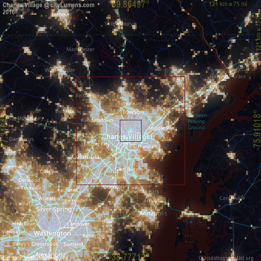
Analysis of Charles Village night lights 2016
Square area 10x10 km:
 91.84%
90-99
8.16%80-89
0%70-79
0%60-69
0%50-59
0%40-49
0%30-39
0%20-29
0%10-19
0%0-9
0%Square area 50x50 km:
19.36%90-99
14.81%80-89
7.14%70-79
8.49%60-69
7.88%50-59
6.44%40-49
5.71%30-39
5.3%20-29
6.33%10-19
8.37%0-9
10.17%Clear (daylight) street map image can be seen on geolist.org.
Map coordinates:
39° 51' 53.9" North, 77° 18' 59.1" West
39° 19' 23.4" North, 76° 36' 47.9" West
38° 46' 37.6" North, 75° 54' 36.6" West
Some cities around Charles Village sort by population:
• Baltimore
3.6 km =2.2 mi,  178°
178°
• Towson
8.8 km =5.5 mi,  6°
6°
• Woodlawn
9.9 km =6.2 mi,  269°
269°
• Parkville
8.7 km =5.4 mi,  46°
46°
• Lochearn
9.6 km =6 mi,  281°
281°
• Rosedale
8.4 km =5.2 mi,  92°
92°
• Overlea
9.1 km =5.7 mi,  60°
60°
• Lansdowne
9.6 km =6 mi,  205°
205°
4351065 (p: 8,267)
Sources (retrieved 2019-11-25):
» Earth at Night: Flat Maps 2012, 2016