Lansdowne night lights from space
Night Light of Lansdowne (Maryland) from space (United States) Src. Average luminocity for 10x10km area is 96.733% and for 50x50km: 67.9844%.
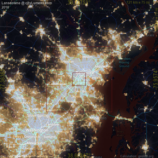
Analysis of Lansdowne night lights 2016
Square area 10x10 km:
 53.91%
90-99
33.16%80-89
7.99%70-79
4.76%60-69
0.17%50-59
0%40-49
0%30-39
0%20-29
0%10-19
0%0-9
0%Square area 50x50 km:
20.3%90-99
16.27%80-89
8.05%70-79
9.57%60-69
9.56%50-59
8.54%40-49
6.5%30-39
6.48%20-29
4.8%10-19
5.13%0-9
4.8%Clear (daylight) street map image can be seen on geolist.org.
Map coordinates:
39° 47' 15.1" North, 77° 21' 49.1" West
39° 14' 42.4" North, 76° 39' 37.9" West
38° 41' 54.5" North, 75° 57' 26.6" West
Some cities around Lansdowne sort by population:
• Baltimore
6.5 km =4 mi,  39°
39°
• Catonsville
6.8 km =4.2 mi,  295°
295°
• Arbutus
3.6 km =2.2 mi,  287°
287°
• Elkridge
5.8 km =3.6 mi,  231°
231°
• Brooklyn Park
4.2 km =2.6 mi,  115°
115°
• Linthicum
4.5 km =2.8 mi,  171°
171°
• Baltimore Highlands
2.4 km =1.5 mi, 122°
• Pumphrey
3.7 km =2.3 mi,  146°
146°
4360328 (p: 8,409)
Sources (retrieved 2019-11-25):
» Earth at Night: Flat Maps 2012, 2016