Chardon night lights from space
Night Light of Chardon (Ohio) from space (United States) Src. Average luminocity for 10x10km area is 8.3247% and for 50x50km: 17.9818%.
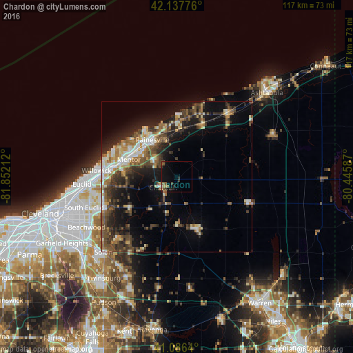
Analysis of Chardon night lights 2016
Square area 10x10 km:
 0.32%
0.32%90-99
0%80-89
0.49%70-79
0.97%60-69
1.3%50-59
2.76%40-49
1.14%30-39
2.27%20-29
1.95%10-19
9.09%0-9
79.71%Square area 50x50 km:
1.99%90-99
2.91%80-89
1.97%70-79
1.9%60-69
2.43%50-59
3.02%40-49
3.86%30-39
3.54%20-29
5.46%10-19
10.15%0-9
62.78%Clear (daylight) street map image can be seen on geolist.org.
Map coordinates:
42° 8' 15.9" North, 81° 51' 7.6" West
41° 36' 51.2" North, 81° 8' 56.4" West
41° 5' 11" North, 80° 26' 45.1" West
Some cities around Chardon sort by population:
• Mentor
16.9 km =10.5 mi,  290°
290°
• Willoughby
21.6 km =13.4 mi,  277°
277°
• Painesville
14.7 km =9.1 mi,  326°
326°
• Wickliffe
25.3 km =15.7 mi,  267°
267°
• Willoughby Hills
22.5 km =14 mi, 265°
• North Madison
22.5 km =14 mi,  21°
21°
• Mentor-on-the-Lake
20.3 km =12.6 mi,  299°
299°
• Kirtland
17.7 km =11 mi, 275°
5149818 (p: 5,148)
Sources (retrieved 2019-11-25):
» Earth at Night: Flat Maps 2012, 2016