Campbellsville night lights from space
Night Light of Campbellsville (Kentucky) from space (United States) Src. Average luminocity for 10x10km area is 31.5633% and for 50x50km: 2.7179%.
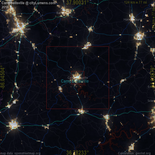
Analysis of Campbellsville night lights 2016
Square area 10x10 km:
 3.57%
3.57%90-99
3.73%80-89
2.92%70-79
3.41%60-69
6.33%50-59
7.47%40-49
2.92%30-39
7.14%20-29
6.66%10-19
31.98%0-9
23.86%Square area 50x50 km:
0.23%90-99
0.3%80-89
0.31%70-79
0.27%60-69
0.37%50-59
0.51%40-49
0.26%30-39
0.63%20-29
0.48%10-19
2.2%0-9
94.44%Clear (daylight) street map image can be seen on geolist.org.
Map coordinates:
37° 54' 1.1" North, 86° 2' 42.1" West
37° 20' 36.2" North, 85° 20' 30.9" West
36° 46' 56.4" North, 84° 38' 19.6" West
Some cities around Campbellsville sort by population:
• Elizabethtown
60 km =37.3 mi,  310°
310°
• Danville
60.5 km =37.6 mi,  56°
56°
• Glasgow
63.6 km =39.5 mi,  232°
232°
• Bardstown
53 km =32.9 mi,  347°
347°
• Somerset
71.1 km =44.2 mi,  113°
113°
• Harrodsburg
64 km =39.8 mi,  43°
43°
• Monticello
71.9 km =44.7 mi,  142°
142°
• Lebanon
26.4 km =16.4 mi,  17°
17°
4286717 (p: 11,237)
Sources (retrieved 2019-11-25):
» Earth at Night: Flat Maps 2012, 2016