Somerset night lights from space
Night Light of Somerset (Kentucky) from space (United States) Src. Average luminocity for 10x10km area is 53.8333% and for 50x50km: 5.2906%.
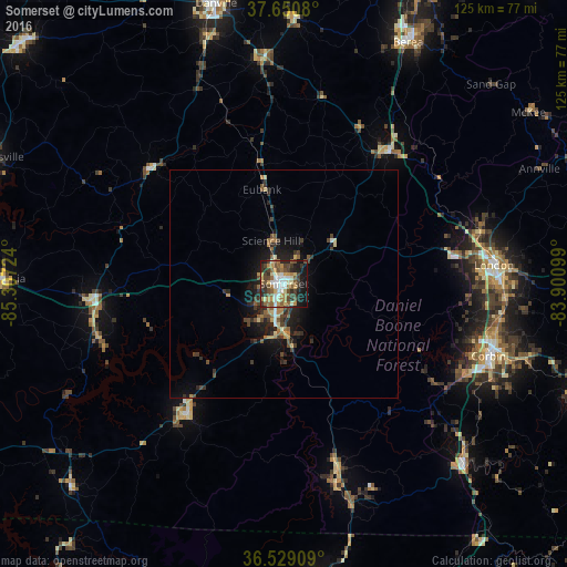
Analysis of Somerset night lights 2016
Square area 10x10 km:
 7.14%
7.14%90-99
10.54%80-89
6.12%70-79
9.86%60-69
8.16%50-59
10.03%40-49
11.39%30-39
9.52%20-29
10.03%10-19
15.99%0-9
1.19%Square area 50x50 km:
0.35%90-99
0.57%80-89
0.58%70-79
0.66%60-69
0.87%50-59
0.88%40-49
1.21%30-39
1.34%20-29
1.53%10-19
3.77%0-9
88.24%Clear (daylight) street map image can be seen on geolist.org.
Map coordinates:
37° 39' 2.9" North, 85° 18' 26.1" West
37° 5' 31.3" North, 84° 36' 14.8" West
36° 31' 44.7" North, 83° 54' 3.6" West
Some cities around Somerset sort by population:
• Danville
63.3 km =39.3 mi,  346°
346°
• Berea
59.6 km =37 mi,  27°
27°
• Campbellsville
71.1 km =44.2 mi,  293°
293°
• Harrodsburg
77.5 km =48.2 mi,  344°
344°
• London
46.4 km =28.8 mi,  84°
84°
• Corbin
47.8 km =29.7 mi,  109°
109°
• Monticello
36.4 km =22.6 mi,  216°
216°
• Williamsburg
55.3 km =34.4 mi,  134°
134°
4308922 (p: 11,439)
Sources (retrieved 2019-11-25):
» Earth at Night: Flat Maps 2012, 2016