Lebanon night lights from space
Night Light of Lebanon (Kentucky) from space (United States) Src. Average luminocity for 10x10km area is 23.4123% and for 50x50km: 2.8461%.
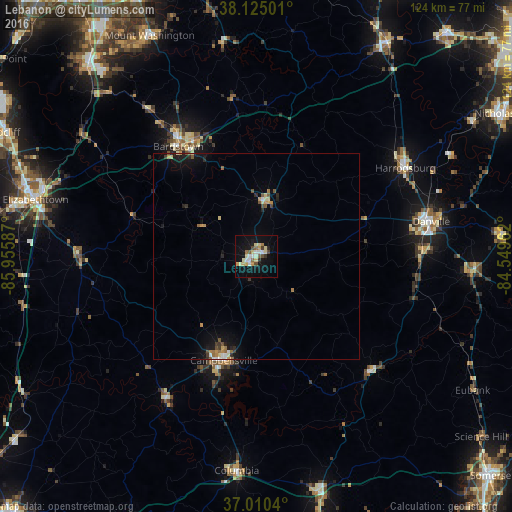
Analysis of Lebanon night lights 2016
Square area 10x10 km:
 2.27%
2.27%90-99
4.22%80-89
6.01%70-79
2.44%60-69
2.11%50-59
1.79%40-49
2.44%30-39
1.95%20-29
1.14%10-19
23.54%0-9
52.11%Square area 50x50 km:
0.19%90-99
0.33%80-89
0.48%70-79
0.42%60-69
0.29%50-59
0.37%40-49
0.34%30-39
0.31%20-29
0.38%10-19
2.44%0-9
94.45%Clear (daylight) street map image can be seen on geolist.org.
Map coordinates:
38° 7' 30" North, 85° 57' 21.1" West
37° 34' 11.2" North, 85° 15' 9.9" West
37° 0' 37.4" North, 84° 32' 58.6" West
Some cities around Lebanon sort by population:
• Elizabethtown
55.2 km =34.3 mi,  284°
284°
• Danville
43.2 km =26.8 mi,  78°
78°
• Mount Washington
59.3 km =36.8 mi,  334°
334°
• Bardstown
32.6 km =20.3 mi,  324°
324°
• Campbellsville
26.4 km =16.4 mi,  197°
197°
• Lawrenceburg
60.7 km =37.7 mi,  31°
31°
• Harrodsburg
41.9 km =26 mi,  59°
59°
• Wilmore
61.3 km =38.1 mi, 57°
4297653 (p: 5,680)
Sources (retrieved 2019-11-25):
» Earth at Night: Flat Maps 2012, 2016