Bardstown night lights from space
Night Light of Bardstown (Kentucky) from space (United States) Src. Average luminocity for 10x10km area is 37.3741% and for 50x50km: 6.7044%.
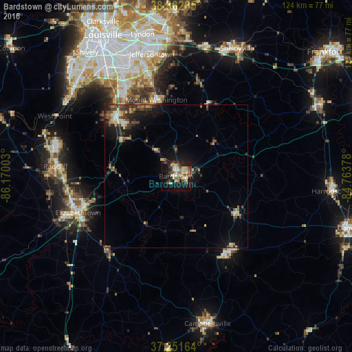
Analysis of Bardstown night lights 2016
Square area 10x10 km:
 2.72%
2.72%90-99
4.93%80-89
10.37%70-79
5.61%60-69
3.06%50-59
6.12%40-49
6.97%30-39
3.74%20-29
6.8%10-19
31.29%0-9
18.37%Square area 50x50 km:
0.34%90-99
0.6%80-89
1.04%70-79
1.05%60-69
0.67%50-59
1.11%40-49
1.46%30-39
1.47%20-29
1.83%10-19
5.05%0-9
85.37%Clear (daylight) street map image can be seen on geolist.org.
Map coordinates:
38° 21' 45.5" North, 86° 10' 12.1" West
37° 48' 33.2" North, 85° 28' 0.8" West
37° 15' 5.9" North, 84° 45' 49.6" West
Some cities around Bardstown sort by population:
• Elizabethtown
36.8 km =22.9 mi,  249°
249°
• Fern Creek
40.4 km =25.1 mi,  344°
344°
• Highview
39.6 km =24.6 mi, 339°
• Mount Washington
27.7 km =17.2 mi,  345°
345°
• Shepherdsville
29.6 km =18.4 mi,  312°
312°
• Fairdale
41.7 km =25.9 mi,  322°
322°
• Hillview
34.7 km =21.6 mi,  326°
326°
• Lebanon
32.6 km =20.3 mi,  144°
144°
4283133 (p: 13,091)
Sources (retrieved 2019-11-25):
» Earth at Night: Flat Maps 2012, 2016