Danville night lights from space
Night Light of Danville (Kentucky) from space (United States) Src. Average luminocity for 10x10km area is 39.119% and for 50x50km: 5.9476%.
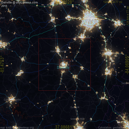
Analysis of Danville night lights 2016
Square area 10x10 km:
 6.63%
6.63%90-99
7.48%80-89
4.93%70-79
4.08%60-69
5.1%50-59
5.78%40-49
3.91%30-39
4.25%20-29
11.73%10-19
34.35%0-9
11.73%Square area 50x50 km:
0.49%90-99
0.59%80-89
0.79%70-79
0.6%60-69
0.76%50-59
0.8%40-49
0.89%30-39
1.22%20-29
1.66%10-19
4.56%0-9
87.63%Clear (daylight) street map image can be seen on geolist.org.
Map coordinates:
38° 12' 1" North, 85° 28' 31.1" West
37° 38' 44.3" North, 84° 46' 19.8" West
37° 5' 12.5" North, 84° 4' 8.6" West
Some cities around Danville sort by population:
• Richmond
43.5 km =27 mi,  74°
74°
• Nicholasville
31.5 km =19.6 mi,  33°
33°
• Berea
42.8 km =26.6 mi,  101°
101°
• Lawrenceburg
44.9 km =27.9 mi,  345°
345°
• Harrodsburg
14.4 km =8.9 mi,  334°
334°
• Wilmore
25.9 km =16.1 mi,  21°
21°
• Monticello
43.2 km =26.8 mi, 26°
• Lebanon
43.2 km =26.8 mi,  258°
258°
4289445 (p: 16,690)
Sources (retrieved 2019-11-25):
» Earth at Night: Flat Maps 2012, 2016