Burnet night lights from space
Night Light of Burnet (Texas) from space (United States) Src. Average luminocity for 10x10km area is 16.3024% and for 50x50km: 4.1834%.
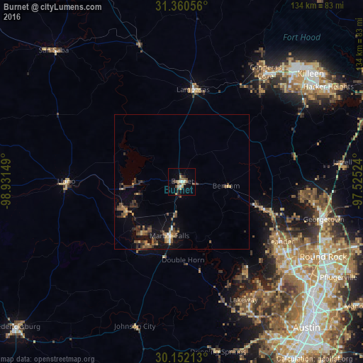
Analysis of Burnet night lights 2016
Square area 10x10 km:
 0.35%
0.35%90-99
2.8%80-89
2.97%70-79
1.57%60-69
0.35%50-59
5.42%40-49
3.5%30-39
1.57%20-29
2.1%10-19
2.8%0-9
76.57%Square area 50x50 km:
0.14%90-99
0.22%80-89
0.6%70-79
0.49%60-69
0.46%50-59
1.05%40-49
0.98%30-39
1.07%20-29
0.79%10-19
2.98%0-9
91.23%Clear (daylight) street map image can be seen on geolist.org.
Map coordinates:
31° 21' 38" North, 98° 55' 53.4" West
30° 45' 29.7" North, 98° 13' 42.1" West
30° 9' 7.7" North, 97° 31' 30.9" West
Some cities around Burnet sort by population:
• Cedar Park
48.1 km =29.9 mi,  125°
125°
• Leander
41.1 km =25.5 mi,  119°
119°
• Lakeway
49.9 km =31 mi,  151°
151°
• Lampasas
34.3 km =21.3 mi,  7°
7°
• Lago Vista
40.3 km =25 mi, 145°
• Marble Falls
20.5 km =12.7 mi,  192°
192°
• Kingsland
23.1 km =14.4 mi,  241°
241°
• Granite Shoals
24 km =14.9 mi,  218°
218°
4677592 (p: 6,239)
Sources (retrieved 2019-11-25):
» Earth at Night: Flat Maps 2012, 2016