Brookdale night lights from space
Night Light of Brookdale (New Jersey) from space (United States) Src. Average luminocity for 10x10km area is 96.3027% and for 50x50km: 80.4715%.
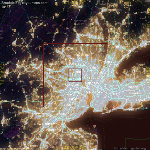
Analysis of Brookdale night lights 2016
Square area 10x10 km:
 48.64%
90-99
35.03%80-89
15.14%70-79
1.19%60-69
0%50-59
0%40-49
0%30-39
0%20-29
0%10-19
0%0-9
0%Square area 50x50 km:
35.21%90-99
17.86%80-89
7.9%70-79
10.73%60-69
11.24%50-59
5.94%40-49
2.46%30-39
2.35%20-29
2.07%10-19
1.69%0-9
2.54%Clear (daylight) street map image can be seen on geolist.org.
Map coordinates:
41° 21' 48.9" North, 74° 53' 9.8" West
40° 50' 1.4" North, 74° 10' 58.5" West
40° 17' 58.5" North, 73° 28' 47.3" West
Some cities around Brookdale sort by population:
• Clifton
3.2 km =2 mi,  30°
30°
• Bloomfield
3 km =1.9 mi,  184°
184°
• Montclair
2.4 km =1.5 mi,  248°
248°
• Nutley
2.3 km =1.4 mi,  123°
123°
• Cedar Grove
4.4 km =2.7 mi,  297°
297°
• Upper Montclair
2.1 km =1.3 mi,  312°
312°
• Little Falls
4.5 km =2.8 mi,  331°
331°
• Glen Ridge
3.6 km =2.2 mi,  209°
209°
5096049 (p: 9,239)
Sources (retrieved 2019-11-25):
» Earth at Night: Flat Maps 2012, 2016