Berea night lights from space
Night Light of Berea (Kentucky) from space (United States) Src. Average luminocity for 10x10km area is 37.3523% and for 50x50km: 7.7389%.
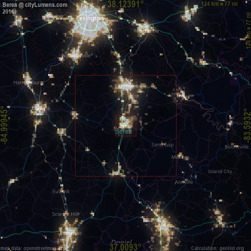
Analysis of Berea night lights 2016
Square area 10x10 km:
 3.9%
3.9%90-99
6.49%80-89
5.52%70-79
3.08%60-69
7.14%50-59
4.71%40-49
8.93%30-39
6.33%20-29
7.31%10-19
30.52%0-9
16.07%Square area 50x50 km:
0.65%90-99
1.06%80-89
0.89%70-79
0.68%60-69
1.17%50-59
1.16%40-49
1.42%30-39
1.86%20-29
2.99%10-19
5.71%0-9
82.43%Clear (daylight) street map image can be seen on geolist.org.
Map coordinates:
38° 7' 26.1" North, 84° 59' 58" West
37° 34' 7.3" North, 84° 17' 46.8" West
37° 0' 33.5" North, 83° 35' 35.5" West
Some cities around Berea sort by population:
• Lexington
49.3 km =30.6 mi,  341°
341°
• Richmond
19.9 km =12.4 mi,  0°
0°
• Nicholasville
42.4 km =26.3 mi,  324°
324°
• Winchester
48 km =29.8 mi,  12°
12°
• Danville
42.8 km =26.6 mi,  281°
281°
• London
52.4 km =32.6 mi,  158°
158°
• Wilmore
45.8 km =28.5 mi, 315°
• Monticello
52.1 km =32.4 mi,  334°
334°
4283974 (p: 14,882)
Sources (retrieved 2019-11-25):
» Earth at Night: Flat Maps 2012, 2016