London night lights from space
Night Light of London (Kentucky) from space (United States) Src. Average luminocity for 10x10km area is 57.1224% and for 50x50km: 10.1363%.
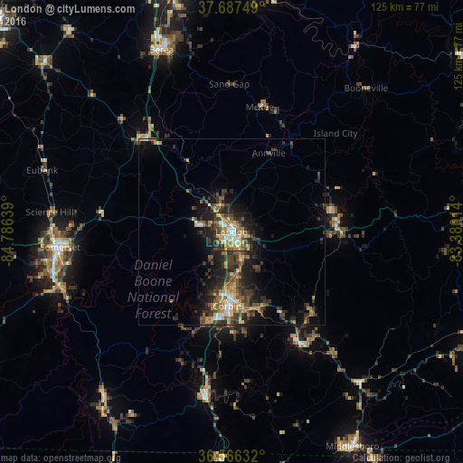
Analysis of London night lights 2016
Square area 10x10 km:
 7.31%
7.31%90-99
6.97%80-89
12.07%70-79
12.24%60-69
9.69%50-59
9.35%40-49
9.86%30-39
11.05%20-29
11.56%10-19
8.67%0-9
1.19%Square area 50x50 km:
0.67%90-99
0.82%80-89
1.51%70-79
1.37%60-69
1.47%50-59
1.86%40-49
1.94%30-39
3.15%20-29
3.74%10-19
6.16%0-9
77.3%Clear (daylight) street map image can be seen on geolist.org.
Map coordinates:
37° 41' 15" North, 84° 47' 11" West
37° 7' 44.3" North, 84° 4' 59.7" West
36° 33' 58.8" North, 83° 22' 48.5" West
Some cities around London sort by population:
• Richmond
71.3 km =44.3 mi,  344°
344°
• Berea
52.4 km =32.6 mi, 338°
• Somerset
46.4 km =28.8 mi,  264°
264°
• Middlesboro
66.4 km =41.3 mi,  150°
150°
• Corbin
20.1 km =12.5 mi,  183°
183°
• Monticello
75.7 km =47 mi,  243°
243°
• Hazard
80 km =49.7 mi,  80°
80°
• Williamsburg
43.4 km =27 mi,  188°
188°
4298960 (p: 8,126)
Sources (retrieved 2019-11-25):
» Earth at Night: Flat Maps 2012, 2016