Nicholasville night lights from space
Night Light of Nicholasville (Kentucky) from space (United States) Src. Average luminocity for 10x10km area is 39.4302% and for 50x50km: 20.6304%.

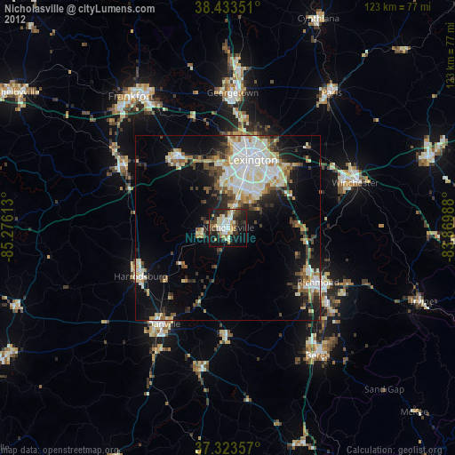
Analysis of Nicholasville night lights 2016
Square area 10x10 km:
 6.66%
6.66%90-99
5.19%80-89
6.49%70-79
5.03%60-69
3.57%50-59
3.57%40-49
3.9%30-39
7.31%20-29
23.54%10-19
27.27%0-9
7.47%Square area 50x50 km:
4.42%90-99
4.84%80-89
2.03%70-79
1.89%60-69
1.77%50-59
1.9%40-49
2.42%30-39
3.1%20-29
5.51%10-19
10.85%0-9
61.27%Clear (daylight) street map image can be seen on geolist.org.
Map coordinates:
38° 26' 0.6" North, 85° 16' 34.1" West
37° 52' 50.3" North, 84° 34' 22.8" West
37° 19' 24.9" North, 83° 52' 11.6" West
Some cities around Nicholasville sort by population:
• Lexington-Fayette
21.3 km =13.2 mi,  28°
28°
• Lexington
14.6 km =9.1 mi, 34°
• Richmond
28.6 km =17.8 mi,  121°
121°
• Danville
31.5 km =19.6 mi,  213°
213°
• Versailles
23.6 km =14.7 mi,  324°
324°
• Harrodsburg
27.1 km =16.8 mi,  241°
241°
• Wilmore
8 km =5 mi,  255°
255°
• Monticello
12.6 km =7.8 mi,  9°
9°
4302561 (p: 29,754)
Sources (retrieved 2019-11-25):
» Earth at Night: Flat Maps 2012, 2016