Benton night lights from space
Night Light of Benton (Illinois) from space (United States) Src. Average luminocity for 10x10km area is 22.9416% and for 50x50km: 6.3023%.
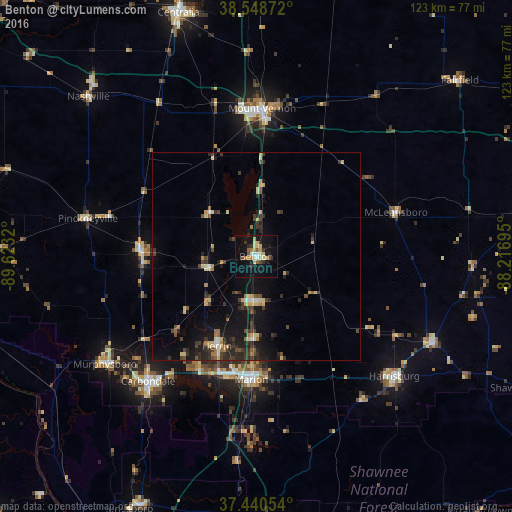
Analysis of Benton night lights 2016
Square area 10x10 km:
 1.79%
1.79%90-99
2.92%80-89
5.03%70-79
3.25%60-69
2.11%50-59
3.08%40-49
1.3%30-39
2.27%20-29
2.76%10-19
31.98%0-9
43.51%Square area 50x50 km:
0.25%90-99
0.5%80-89
1.32%70-79
0.54%60-69
0.58%50-59
0.66%40-49
0.99%30-39
1.72%20-29
1.85%10-19
6.15%0-9
85.44%Clear (daylight) street map image can be seen on geolist.org.
Map coordinates:
38° 32' 55.4" North, 89° 37' 23.5" West
37° 59' 48.2" North, 88° 55' 12.3" West
37° 26' 25.9" North, 88° 13' 1" West
Some cities around Benton sort by population:
• Carbondale
39.7 km =24.7 mi,  220°
220°
• Marion
29.6 km =18.4 mi,  182°
182°
• Mount Vernon
35.7 km =22.2 mi,  2°
2°
• Herrin
23.5 km =14.6 mi,  203°
203°
• West Frankfort
11 km =6.8 mi,  185°
185°
• Du Quoin
27.7 km =17.2 mi,  273°
273°
• Carterville
29.7 km =18.5 mi,  207°
207°
• Pinckneyville
41.5 km =25.8 mi,  282°
282°
4233586 (p: 7,041)
Sources (retrieved 2019-11-25):
» Earth at Night: Flat Maps 2012, 2016