West Frankfort night lights from space
Night Light of West Frankfort (Illinois) from space (United States) Src. Average luminocity for 10x10km area is 21.4886% and for 50x50km: 10.367%.
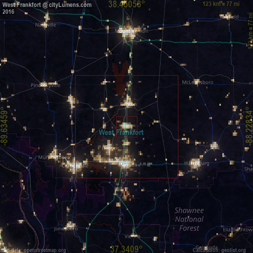
Analysis of West Frankfort night lights 2016
Square area 10x10 km:
 2.27%
2.27%90-99
1.3%80-89
6.17%70-79
0.97%60-69
0.97%50-59
2.6%40-49
1.62%30-39
5.19%20-29
3.9%10-19
31.17%0-9
43.83%Square area 50x50 km:
0.88%90-99
0.98%80-89
1.59%70-79
0.93%60-69
1.24%50-59
1.39%40-49
1.42%30-39
2.71%20-29
3.4%10-19
10.31%0-9
75.15%Clear (daylight) street map image can be seen on geolist.org.
Map coordinates:
38° 27' 2.1" North, 89° 38' 4.5" West
37° 53' 52.2" North, 88° 55' 53.3" West
37° 20' 27.2" North, 88° 13' 42" West
Some cities around West Frankfort sort by population:
• Carbondale
31.4 km =19.5 mi,  232°
232°
• Marion
18.6 km =11.6 mi,  180°
180°
• Herrin
13.5 km =8.4 mi,  218°
218°
• Harrisburg
38.6 km =24 mi,  117°
117°
• Murphysboro
38.4 km =23.9 mi,  247°
247°
• Benton
11 km =6.8 mi,  5°
5°
• Du Quoin
29.6 km =18.4 mi,  295°
295°
• Carterville
20 km =12.4 mi, 219°
4252812 (p: 8,067)
Sources (retrieved 2019-11-25):
» Earth at Night: Flat Maps 2012, 2016