Marion night lights from space
Night Light of Marion (Illinois) from space (United States) Src. Average luminocity for 10x10km area is 45.7228% and for 50x50km: 9.6337%.
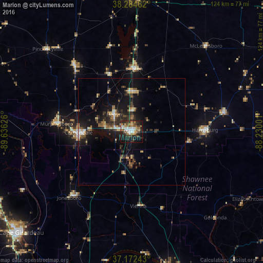
Analysis of Marion night lights 2016
Square area 10x10 km:
 9.18%
9.18%90-99
5.95%80-89
4.59%70-79
5.1%60-69
7.82%50-59
6.97%40-49
5.78%30-39
11.05%20-29
16.84%10-19
23.81%0-9
2.89%Square area 50x50 km:
0.85%90-99
0.79%80-89
1.33%70-79
0.87%60-69
1.17%50-59
1.48%40-49
1.4%30-39
2.87%20-29
3.24%10-19
9.13%0-9
76.87%Clear (daylight) street map image can be seen on geolist.org.
Map coordinates:
38° 17' 4.6" North, 89° 38' 10.5" West
37° 43' 50.2" North, 88° 55' 59.3" West
37° 10' 20.7" North, 88° 13' 48" West
Some cities around Marion sort by population:
• Carbondale
24.9 km =15.5 mi,  269°
269°
• Herrin
11.6 km =7.2 mi,  314°
314°
• Harrisburg
34.5 km =21.4 mi,  88°
88°
• West Frankfort
18.6 km =11.6 mi,  0°
0°
• Murphysboro
35.5 km =22.1 mi,  276°
276°
• Benton
29.6 km =18.4 mi, 2°
• Du Quoin
41 km =25.5 mi,  319°
319°
• Carterville
13.1 km =8.1 mi, 284°
4243899 (p: 17,803)
Sources (retrieved 2019-11-25):
» Earth at Night: Flat Maps 2012, 2016