Bellmore night lights from space
Night Light of Bellmore (New York) from space (United States) Src. Average luminocity for 10x10km area is 85.8945% and for 50x50km: 51.3903%.
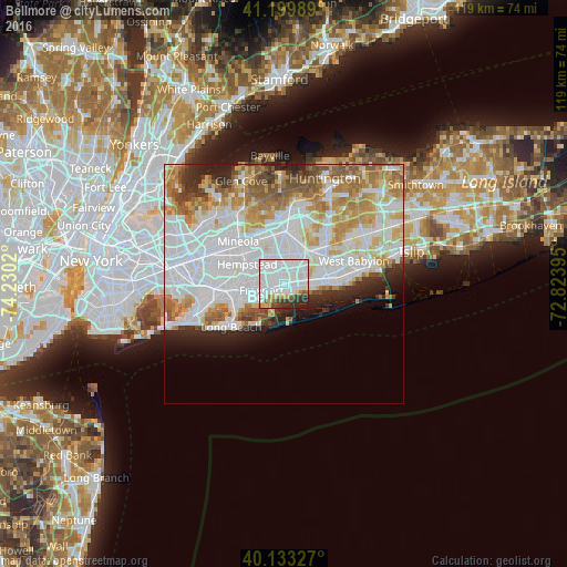
Analysis of Bellmore night lights 2016
Square area 10x10 km:
 49.19%
90-99
23.7%80-89
4.06%70-79
1.95%60-69
3.41%50-59
2.11%40-49
3.57%30-39
7.31%20-29
4.55%10-19
0.16%0-9
0%Square area 50x50 km:
20.61%90-99
12.21%80-89
5.2%70-79
6.23%60-69
5.75%50-59
4.18%40-49
2.45%30-39
2.46%20-29
4.6%10-19
4.13%0-9
32.18%Clear (daylight) street map image can be seen on geolist.org.
Map coordinates:
41° 11' 59.6" North, 74° 13' 48.7" West
40° 40' 7.4" North, 73° 31' 37.5" West
40° 7' 59.8" North, 72° 49' 26.2" West
Some cities around Bellmore sort by population:
• Freeport
4.9 km =3 mi,  255°
255°
• Merrick
2.2 km =1.4 mi,  252°
252°
• Massapequa
4.6 km =2.9 mi,  73°
73°
• North Bellmore
2.6 km =1.6 mi,  347°
347°
• Wantagh
2.2 km =1.4 mi,  40°
40°
• Seaford
3.3 km =2.1 mi,  95°
95°
• North Merrick
3.9 km =2.4 mi,  309°
309°
• North Wantagh
3.2 km =2 mi,  30°
30°
5108707 (p: 16,218)
Sources (retrieved 2019-11-25):
» Earth at Night: Flat Maps 2012, 2016