Aberdeen night lights from space
Night Light of Aberdeen (Maryland) from space (United States) Src. Average luminocity for 10x10km area is 56.3198% and for 50x50km: 19.4215%.
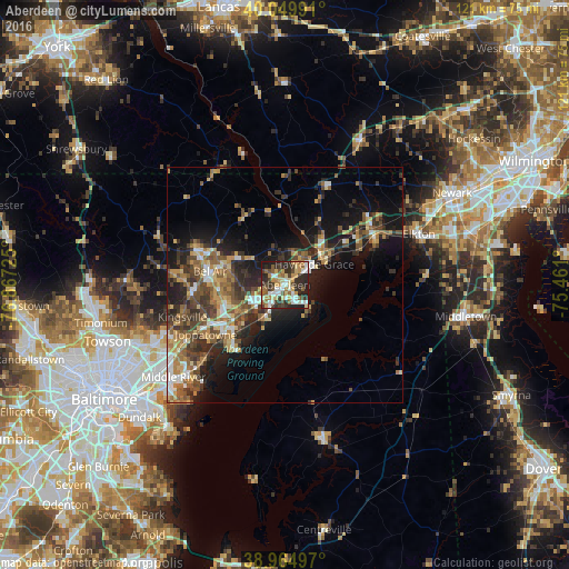
Analysis of Aberdeen night lights 2016
Square area 10x10 km:
 9.25%
9.25%90-99
10.39%80-89
9.9%70-79
8.77%60-69
6.82%50-59
7.79%40-49
7.31%30-39
9.74%20-29
24.35%10-19
5.68%0-9
0%Square area 50x50 km:
1.94%90-99
2.18%80-89
2.53%70-79
2.81%60-69
3.1%50-59
3.78%40-49
3.97%30-39
4.2%20-29
6.02%10-19
10.77%0-9
58.7%Clear (daylight) street map image can be seen on geolist.org.
Map coordinates:
40° 2' 59.7" North, 76° 52' 2.1" West
39° 30' 34.4" North, 76° 9' 50.8" West
38° 57' 53.9" North, 75° 27' 39.6" West
Some cities around Aberdeen sort by population:
• South Bel Air
15.1 km =9.4 mi,  280°
280°
• Bel Air South
13.4 km =8.3 mi,  267°
267°
• North Bel Air
16.7 km =10.4 mi, 281°
• Edgewood
15.1 km =9.4 mi,  227°
227°
• Havre de Grace
7.6 km =4.7 mi,  54°
54°
• Joppatowne
17.4 km =10.8 mi,  250°
250°
• Bel Air
16.1 km =10 mi, 280°
• Riverside
7.7 km =4.8 mi,  238°
238°
4346913 (p: 15,580)
Sources (retrieved 2019-11-25):
» Earth at Night: Flat Maps 2012, 2016