Hawthorn Woods night lights from space
Night Light of Hawthorn Woods (Illinois) from space (United States) Src. Average luminocity for 10x10km area is 62.4833% and for 50x50km: 65.7185%.
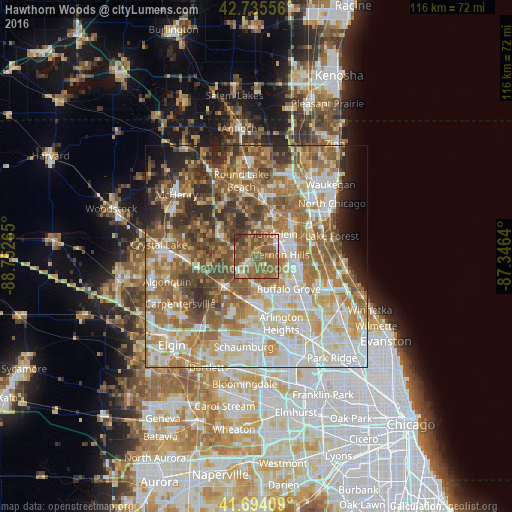
Analysis of Hawthorn Woods night lights 2016
Square area 10x10 km:
 3.48%
3.48%90-99
6.21%80-89
5.3%70-79
11.52%60-69
19.85%50-59
35.91%40-49
13.03%30-39
3.94%20-29
0.76%10-19
0%0-9
0%Square area 50x50 km:
13.34%90-99
14.21%80-89
9.55%70-79
9.39%60-69
13.49%50-59
12.77%40-49
8.92%30-39
5.23%20-29
5.75%10-19
3.56%0-9
3.79%Clear (daylight) street map image can be seen on geolist.org.
Map coordinates:
42° 44' 8" North, 88° 45' 9.5" West
42° 13' 1.1" North, 88° 2' 58.3" West
41° 41' 38.7" North, 87° 20' 47" West
Some cities around Hawthorn Woods sort by population:
• Buffalo Grove
10.4 km =6.5 mi,  134°
134°
• Mundelein
6.4 km =4 mi,  36°
36°
• Vernon Hills
5.8 km =3.6 mi,  87°
87°
• Lake Zurich
4.2 km =2.6 mi,  238°
238°
• Wauconda
8.7 km =5.4 mi,  302°
302°
• Barrington
10 km =6.2 mi,  225°
225°
• Long Grove
6 km =3.7 mi,  135°
135°
• Fairfield
1 km =0.6 mi,  284°
284°
4895376 (p: 7,961)
Sources (retrieved 2019-11-25):
» Earth at Night: Flat Maps 2012, 2016