Mooresville night lights from space
Night Light of Mooresville (Indiana) from space (United States) Src. Average luminocity for 10x10km area is 40.1623% and for 50x50km: 32.7956%.
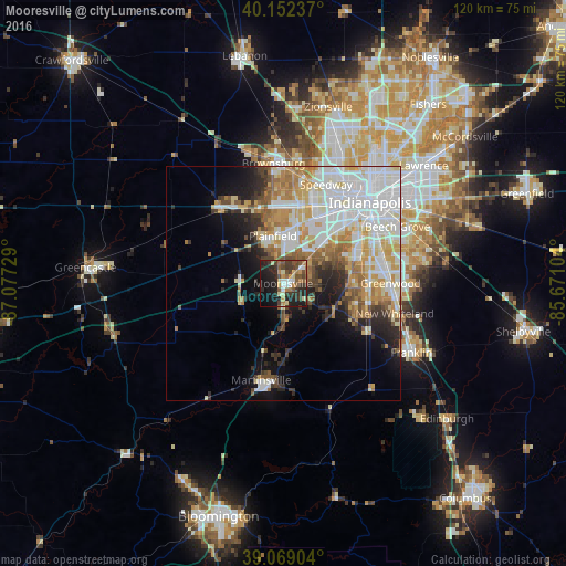
Analysis of Mooresville night lights 2016
Square area 10x10 km:
 3.73%
3.73%90-99
4.38%80-89
4.55%70-79
5.52%60-69
5.36%50-59
9.74%40-49
8.93%30-39
12.34%20-29
15.58%10-19
23.54%0-9
6.33%Square area 50x50 km:
9.46%90-99
7.79%80-89
3.75%70-79
4.48%60-69
4.05%50-59
3.15%40-49
2.38%30-39
2.82%20-29
4.4%10-19
7.61%0-9
50.09%Clear (daylight) street map image can be seen on geolist.org.
Map coordinates:
40° 9' 8.5" North, 87° 4' 38.2" West
39° 36' 46.2" North, 86° 22' 27" West
39° 4' 8.5" North, 85° 40' 15.7" West
Some cities around Mooresville sort by population:
• Greenwood
22.9 km =14.2 mi,  89°
89°
• Plainfield
10.4 km =6.5 mi,  347°
347°
• Fairfield Heights
24 km =14.9 mi,  358°
358°
• Avon
16.8 km =10.4 mi, 352°
• Speedway
23 km =14.3 mi,  23°
23°
• Martinsville
21.1 km =13.1 mi,  192°
192°
• Danville
21 km =13 mi,  321°
321°
• Bargersville
20.4 km =12.7 mi,  120°
120°
4261585 (p: 9,623)
Sources (retrieved 2019-11-25):
» Earth at Night: Flat Maps 2012, 2016