Martinsville night lights from space
Night Light of Martinsville (Indiana) from space (United States) Src. Average luminocity for 10x10km area is 22.1378% and for 50x50km: 8.8427%.
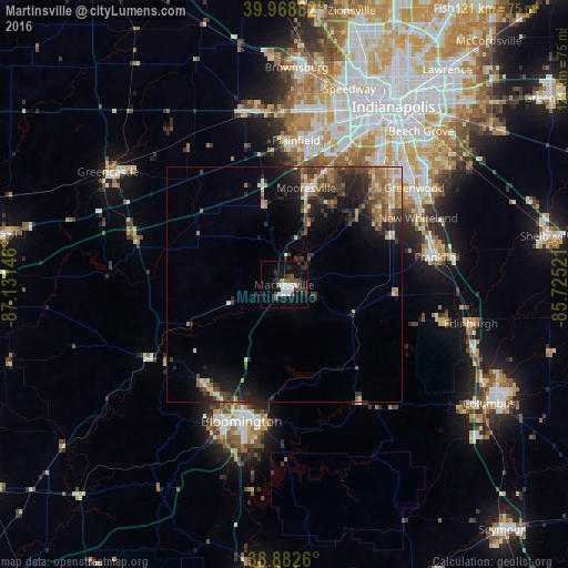
Analysis of Martinsville night lights 2016
Square area 10x10 km:
 4.42%
4.42%90-99
4.42%80-89
0.68%70-79
0.68%60-69
0.68%50-59
4.25%40-49
3.4%30-39
4.42%20-29
4.76%10-19
24.83%0-9
47.45%Square area 50x50 km:
0.6%90-99
0.95%80-89
0.9%70-79
1.41%60-69
1.42%50-59
1.47%40-49
1.62%30-39
2.19%20-29
3.22%10-19
5.81%0-9
80.41%Clear (daylight) street map image can be seen on geolist.org.
Map coordinates:
39° 58' 7.8" North, 87° 7' 53.3" West
39° 25' 40.2" North, 86° 25' 42" West
38° 52' 57.4" North, 85° 43' 30.8" West
Some cities around Martinsville sort by population:
• Bloomington
30.4 km =18.9 mi,  196°
196°
• Greenwood
34.5 km =21.4 mi,  53°
53°
• Plainfield
30.8 km =19.1 mi,  4°
4°
• Franklin
32.6 km =20.3 mi,  79°
79°
• Mooresville
21.1 km =13.1 mi,  12°
12°
• Bargersville
24.6 km =15.3 mi,  65°
65°
• Ellettsville
27.4 km =17 mi,  218°
218°
• New Whiteland
32 km =19.9 mi,  63°
63°
4261032 (p: 11,690)
Sources (retrieved 2019-11-25):
» Earth at Night: Flat Maps 2012, 2016