Balch Springs night lights from space
Night Light of Balch Springs (Texas) from space (United States) Src. Average luminocity for 10x10km area is 86.1049% and for 50x50km: 64.0122%.
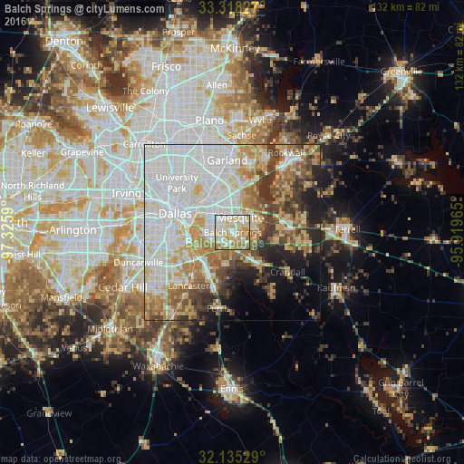
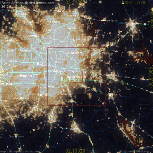
Analysis of Balch Springs night lights 2016
Square area 10x10 km:
 17.66%
90-99
29.9%80-89
23.25%70-79
11.71%60-69
15.73%50-59
1.75%40-49
0%30-39
0%20-29
0%10-19
0%0-9
0%Square area 50x50 km:
20.35%90-99
15.94%80-89
8.33%70-79
7.4%60-69
8.09%50-59
6.16%40-49
5.39%30-39
6.45%20-29
4.85%10-19
6.28%0-9
10.76%Clear (daylight) street map image can be seen on geolist.org.
Map coordinates:
33° 19' 5.8" North, 97° 19' 33.2" West
32° 43' 43.5" North, 96° 37' 22" West
32° 8' 7" North, 95° 55' 10.7" West
Some cities around Balch Springs sort by population:
• Dallas
18.2 km =11.3 mi,  289°
289°
• Mesquite
4.8 km =3 mi,  27°
27°
• Forney
14.3 km =8.9 mi,  81°
81°
• Seagoville
12.7 km =7.9 mi,  141°
141°
• Highland Park
19.6 km =12.2 mi,  306°
306°
• Heath
18.3 km =11.4 mi,  49°
49°
• Sunnyvale
9.5 km =5.9 mi,  37°
37°
• Hutchins
12.2 km =7.6 mi,  223°
223°
4672059 (p: 25,210)
Sources (retrieved 2019-11-25):
» Earth at Night: Flat Maps 2012, 2016