Highland Park night lights from space
Night Light of Highland Park (Texas) from space (United States) Src. Average luminocity for 10x10km area is 99.2378% and for 50x50km: 89.1487%.
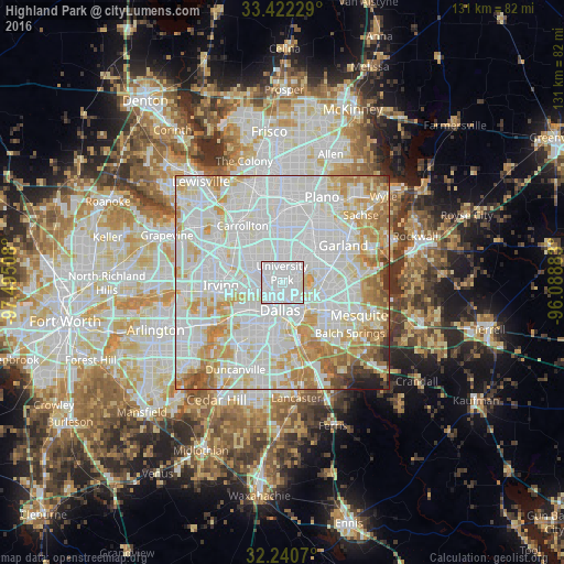
Analysis of Highland Park night lights 2016
Square area 10x10 km:
 68.18%
90-99
31.29%80-89
0.52%70-79
0%60-69
0%50-59
0%40-49
0%30-39
0%20-29
0%10-19
0%0-9
0%Square area 50x50 km:
37.34%90-99
29.75%80-89
10.45%70-79
9.28%60-69
6.84%50-59
2.76%40-49
1.29%30-39
1.01%20-29
0.63%10-19
0.64%0-9
0%Clear (daylight) street map image can be seen on geolist.org.
Map coordinates:
33° 25' 20.2" North, 97° 29' 42.3" West
32° 50' 0.5" North, 96° 47' 31" West
32° 14' 26.5" North, 96° 5' 19.8" West
Some cities around Highland Park sort by population:
• Dallas
5.8 km =3.6 mi,  193°
193°
• Garland
16.8 km =10.4 mi,  58°
58°
• Irving
14.8 km =9.2 mi,  261°
261°
• Carrollton
16.2 km =10.1 mi,  325°
325°
• Richardson
14 km =8.7 mi,  24°
24°
• Farmers Branch
14.2 km =8.8 mi,  316°
316°
• University Park
2 km =1.2 mi,  337°
337°
• Addison
14.7 km =9.1 mi,  346°
346°
4697616 (p: 9,189)
Sources (retrieved 2019-11-25):
» Earth at Night: Flat Maps 2012, 2016