Seagoville night lights from space
Night Light of Seagoville (Texas) from space (United States) Src. Average luminocity for 10x10km area is 35.5962% and for 50x50km: 41.3212%.
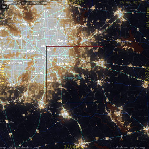
Analysis of Seagoville night lights 2016
Square area 10x10 km:
 2.62%
2.62%90-99
2.62%80-89
4.37%70-79
4.72%60-69
5.77%50-59
5.94%40-49
6.29%30-39
13.46%20-29
14.86%10-19
36.89%0-9
2.45%Square area 50x50 km:
7.62%90-99
8.44%80-89
6.2%70-79
6.03%60-69
6.39%50-59
5.16%40-49
5.11%30-39
7.72%20-29
6.78%10-19
11.14%0-9
29.41%Clear (daylight) street map image can be seen on geolist.org.
Map coordinates:
33° 13' 46.9" North, 97° 14' 29.2" West
32° 38' 22.5" North, 96° 32' 18" West
32° 2' 43.9" North, 95° 50' 6.7" West
Some cities around Seagoville sort by population:
• Mesquite
15.2 km =9.4 mi,  338°
338°
• Lancaster
21.1 km =13.1 mi,  255°
255°
• Balch Springs
12.7 km =7.9 mi,  321°
321°
• Forney
13.6 km =8.5 mi,  27°
27°
• Heath
22.7 km =14.1 mi,  15°
15°
• Kaufman
22.2 km =13.8 mi,  104°
104°
• Sunnyvale
17.6 km =10.9 mi,  353°
353°
• Hutchins
16.4 km =10.2 mi,  273°
273°
4727605 (p: 15,894)
Sources (retrieved 2019-11-25):
» Earth at Night: Flat Maps 2012, 2016