Austell night lights from space
Night Light of Austell (Georgia) from space (United States) Src. Average luminocity for 10x10km area is 84.778% and for 50x50km: 72.0472%.
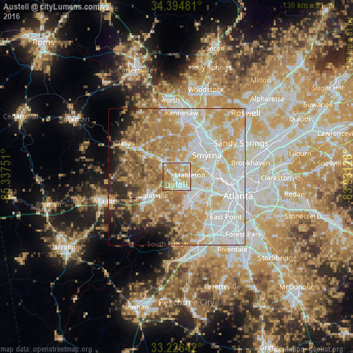
Analysis of Austell night lights 2016
Square area 10x10 km:
 17.48%
90-99
24.48%80-89
15.21%70-79
31.47%60-69
11.36%50-59
0%40-49
0%30-39
0%20-29
0%10-19
0%0-9
0%Square area 50x50 km:
18.99%90-99
15.96%80-89
13.07%70-79
15.18%60-69
12.12%50-59
5.71%40-49
2.72%30-39
3.44%20-29
4.31%10-19
4.81%0-9
3.7%Clear (daylight) street map image can be seen on geolist.org.
Map coordinates:
34° 23' 41.3" North, 85° 20' 15" West
33° 48' 45.4" North, 84° 38' 3.8" West
33° 13' 35.1" North, 83° 55' 52.5" West
Some cities around Austell sort by population:
• Marietta
17.4 km =10.8 mi,  26°
26°
• Smyrna
13.6 km =8.5 mi,  54°
54°
• Mableton
4.8 km =3 mi,  81°
81°
• Douglasville
12.5 km =7.8 mi,  237°
237°
• Lithia Springs
3.2 km =2 mi,  229°
229°
• Powder Springs
6.9 km =4.3 mi,  318°
318°
• Vinings
16.7 km =10.4 mi,  69°
69°
• Fair Oaks
14.2 km =8.8 mi,  35°
35°
4180564 (p: 7,107)
Sources (retrieved 2019-11-25):
» Earth at Night: Flat Maps 2012, 2016