Auburn night lights from space
Night Light of Auburn (California) from space (United States) Src. Average luminocity for 10x10km area is 23.9575% and for 50x50km: 17.2478%.
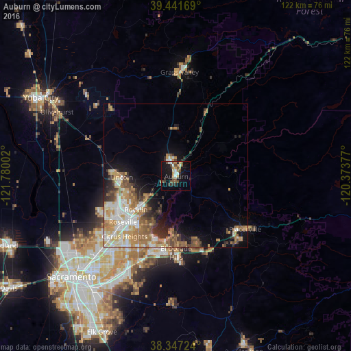
Analysis of Auburn night lights 2016
Square area 10x10 km:
 3.4%
3.4%90-99
2.55%80-89
0.34%70-79
3.91%60-69
3.06%50-59
4.93%40-49
5.61%30-39
3.4%20-29
3.4%10-19
25.85%0-9
43.54%Square area 50x50 km:
2.87%90-99
3.27%80-89
1.72%70-79
3.38%60-69
3.35%50-59
2.47%40-49
2%30-39
2.08%20-29
2.22%10-19
6.24%0-9
70.39%Clear (daylight) street map image can be seen on geolist.org.
Map coordinates:
39° 26' 30.1" North, 121° 46' 48.1" West
38° 53' 47.7" North, 121° 4' 36.8" West
38° 20' 50.1" North, 120° 22' 25.6" West
Some cities around Auburn sort by population:
• Roseville
24.3 km =15.1 mi,  228°
228°
• Folsom
25.8 km =16 mi,  199°
199°
• Rocklin
18.1 km =11.2 mi, 229°
• Lincoln
18.7 km =11.6 mi,  268°
268°
• El Dorado Hills
23.4 km =14.5 mi,  181°
181°
• Granite Bay
16.6 km =10.3 mi,  206°
206°
• North Auburn
3.9 km =2.4 mi,  353°
353°
• Loomis
13.1 km =8.1 mi, 230°
5325223 (p: 13,953)
Sources (retrieved 2019-11-25):
» Earth at Night: Flat Maps 2012, 2016