North Auburn night lights from space
Night Light of North Auburn (California) from space (United States) Src. Average luminocity for 10x10km area is 28.898% and for 50x50km: 13.4908%.
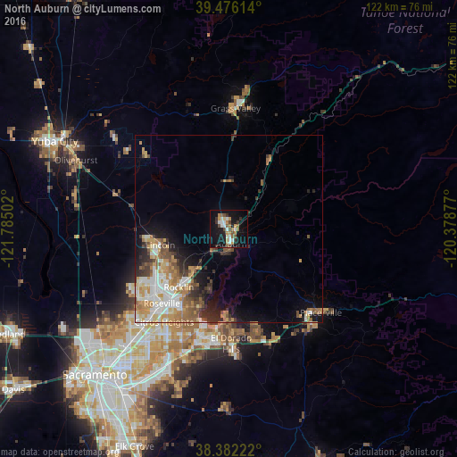
Analysis of North Auburn night lights 2016
Square area 10x10 km:
 4.93%
4.93%90-99
4.42%80-89
1.02%70-79
5.78%60-69
3.57%50-59
3.74%40-49
4.42%30-39
3.23%20-29
2.89%10-19
34.18%0-9
31.8%Square area 50x50 km:
2.35%90-99
2.53%80-89
1.19%70-79
2.59%60-69
2.31%50-59
1.83%40-49
1.54%30-39
1.85%20-29
2.13%10-19
5.56%0-9
76.09%Clear (daylight) street map image can be seen on geolist.org.
Map coordinates:
39° 28' 34.1" North, 121° 47' 6.1" West
38° 55' 52.6" North, 121° 4' 54.8" West
38° 22' 56" North, 120° 22' 43.6" West
Some cities around North Auburn sort by population:
• Roseville
26.7 km =16.6 mi,  221°
221°
• Rocklin
20.5 km =12.7 mi, 220°
• Lincoln
18.8 km =11.7 mi,  256°
256°
• El Dorado Hills
27.3 km =17 mi,  180°
180°
• Granite Bay
20 km =12.4 mi,  200°
200°
• Auburn
3.9 km =2.4 mi,  173°
173°
• Alta Sierra
23.5 km =14.6 mi,  5°
5°
• Loomis
15.6 km =9.7 mi, 218°
5377266 (p: 13,022)
Sources (retrieved 2019-11-25):
» Earth at Night: Flat Maps 2012, 2016