Ashton-Sandy Spring night lights from space
Night Light of Ashton-Sandy Spring (Maryland) from space (United States) Src. Average luminocity for 10x10km area is 48.8149% and for 50x50km: 63.679%.
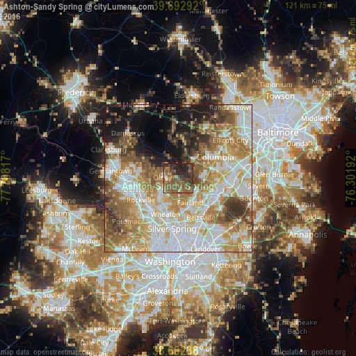
Analysis of Ashton-Sandy Spring night lights 2016
Square area 10x10 km:
 0.16%
0.16%90-99
2.6%80-89
3.9%70-79
7.14%60-69
11.69%50-59
28.9%40-49
10.71%30-39
14.61%20-29
16.4%10-19
3.9%0-9
0%Square area 50x50 km:
15.99%90-99
14.19%80-89
8.51%70-79
10.48%60-69
10.42%50-59
9.15%40-49
5.85%30-39
5.62%20-29
4.87%10-19
8.99%0-9
5.93%Clear (daylight) street map image can be seen on geolist.org.
Map coordinates:
39° 41' 34.5" North, 77° 42' 29.4" West
39° 8' 59.1" North, 77° 0' 18.1" West
38° 36' 8.6" North, 76° 18' 6.9" West
Some cities around Ashton-Sandy Spring sort by population:
• Olney
5.3 km =3.3 mi,  274°
274°
• Scaggsville
9.1 km =5.7 mi,  93°
93°
• Cloverly
4.7 km =2.9 mi,  172°
172°
• Colesville
8.2 km =5.1 mi,  178°
178°
• Leisure World
7.6 km =4.7 mi,  226°
226°
• Rossmoor
7.7 km =4.8 mi, 228°
• Burtonsville
7.6 km =4.7 mi,  124°
124°
• Layhill
7.2 km =4.5 mi,  208°
208°
7257953 (p: 5,628)
Sources (retrieved 2019-11-25):
» Earth at Night: Flat Maps 2012, 2016