Colesville night lights from space
Night Light of Colesville (Maryland) from space (United States) Src. Average luminocity for 10x10km area is 76.6347% and for 50x50km: 72.7083%.
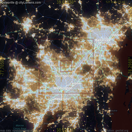
Analysis of Colesville night lights 2016
Square area 10x10 km:
 13.15%
90-99
15.75%80-89
9.25%70-79
22.08%60-69
23.38%50-59
15.75%40-49
0.65%30-39
0%20-29
0%10-19
0%0-9
0%Square area 50x50 km:
22.04%90-99
17.17%80-89
9.89%70-79
12%60-69
10.6%50-59
8.35%40-49
5.05%30-39
4.51%20-29
3.41%10-19
4.03%0-9
2.94%Clear (daylight) street map image can be seen on geolist.org.
Map coordinates:
39° 37' 9.8" North, 77° 42' 18.2" West
39° 4' 32.4" North, 77° 0' 6.9" West
38° 31' 39.8" North, 76° 17' 55.7" West
Some cities around Colesville sort by population:
• Fairland
3.8 km =2.4 mi,  89°
89°
• Calverton
6 km =3.7 mi,  109°
109°
• White Oak
4.1 km =2.5 mi,  169°
169°
• Cloverly
3.6 km =2.2 mi,  5°
5°
• Glenmont
4.6 km =2.9 mi,  244°
244°
• Kemp Mill
4.3 km =2.7 mi,  200°
200°
• Hillandale
6 km =3.7 mi,  156°
156°
• Layhill
4.1 km =2.5 mi,  296°
296°
4351951 (p: 14,647)
Sources (retrieved 2019-11-25):
» Earth at Night: Flat Maps 2012, 2016