Burtonsville night lights from space
Night Light of Burtonsville (Maryland) from space (United States) Src. Average luminocity for 10x10km area is 69.8799% and for 50x50km: 70.4634%.
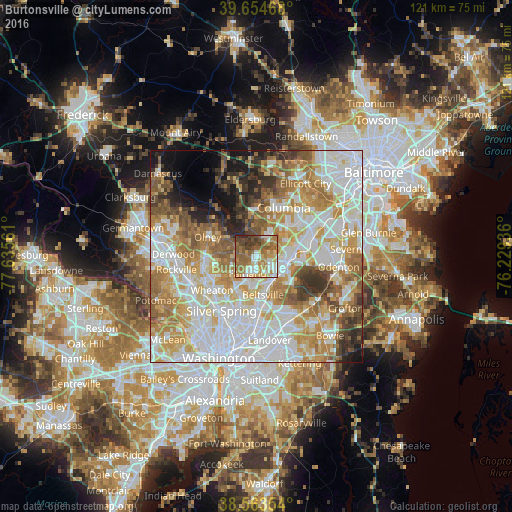
Analysis of Burtonsville night lights 2016
Square area 10x10 km:
 8.28%
8.28%90-99
16.07%80-89
9.09%70-79
14.94%60-69
18.83%50-59
15.91%40-49
8.6%30-39
6.17%20-29
2.11%10-19
0%0-9
0%Square area 50x50 km:
21.26%90-99
16.94%80-89
9.05%70-79
11.69%60-69
9.93%50-59
8.11%40-49
4.61%30-39
4.99%20-29
3.82%10-19
5.11%0-9
4.49%Clear (daylight) street map image can be seen on geolist.org.
Map coordinates:
39° 39' 16.8" North, 77° 38' 8.2" West
39° 6' 40.4" North, 76° 55' 56.9" West
38° 33' 48.7" North, 76° 13' 45.7" West
Some cities around Burtonsville sort by population:
• Laurel
7.4 km =4.6 mi,  100°
100°
• Scaggsville
4.7 km =2.9 mi,  36°
36°
• Fairland
4.5 km =2.8 mi,  209°
209°
• Calverton
6 km =3.7 mi,  182°
182°
• Cloverly
5.6 km =3.5 mi,  266°
266°
• Colesville
7.2 km =4.5 mi,  236°
236°
• Riverside
8 km =5 mi,  30°
30°
• Ashton-Sandy Spring
7.6 km =4.7 mi,  304°
304°
4349903 (p: 8,323)
Sources (retrieved 2019-11-25):
» Earth at Night: Flat Maps 2012, 2016