Loudon night lights from space
Night Light of Loudon (Tennessee) from space (United States) Src. Average luminocity for 10x10km area is 30.8059% and for 50x50km: 20.9305%.
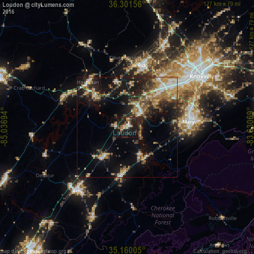
Analysis of Loudon night lights 2016
Square area 10x10 km:
 1.92%
1.92%90-99
2.97%80-89
3.5%70-79
3.5%60-69
4.02%50-59
6.12%40-49
3.5%30-39
5.77%20-29
18.01%10-19
43.01%0-9
7.69%Square area 50x50 km:
1.91%90-99
2.21%80-89
3.35%70-79
2.85%60-69
3.32%50-59
3.2%40-49
2.92%30-39
4.66%20-29
5.97%10-19
16.69%0-9
52.91%Clear (daylight) street map image can be seen on geolist.org.
Map coordinates:
36° 18' 5.6" North, 85° 2' 13" West
35° 43' 58.3" North, 84° 20' 1.7" West
35° 9' 36.2" North, 83° 37' 50.5" West
Some cities around Loudon sort by population:
• Oak Ridge
31.4 km =19.5 mi,  10°
10°
• Maryville
32.9 km =20.4 mi,  85°
85°
• Farragut
23.4 km =14.5 mi,  43°
43°
• Lenoir City
10 km =6.2 mi, 44°
• Harriman
29.8 km =18.5 mi,  318°
318°
• Sweetwater
18.6 km =11.6 mi,  218°
218°
• Kingston
22.8 km =14.2 mi, 316°
• Tellico Village
9 km =5.6 mi,  127°
127°
4638278 (p: 5,731)
Sources (retrieved 2019-11-25):
» Earth at Night: Flat Maps 2012, 2016