Addison night lights from space
Night Light of Addison (Texas) from space (United States) Src. Average luminocity for 10x10km area is 99.0513% and for 50x50km: 89.9179%.
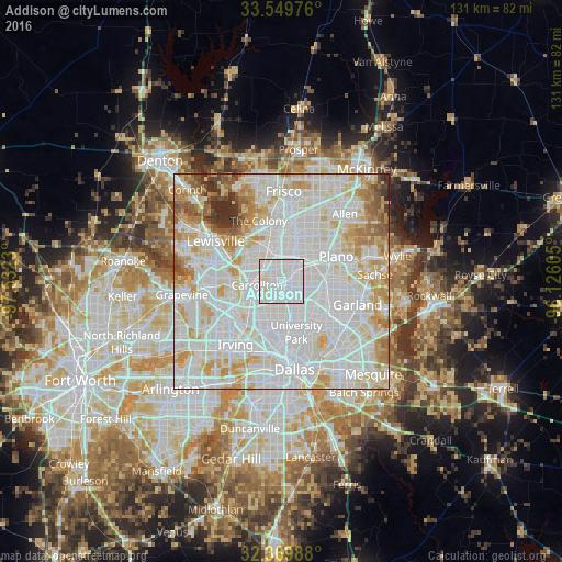
Analysis of Addison night lights 2016
Square area 10x10 km:
 65.75%
90-99
32.6%80-89
1.65%70-79
0%60-69
0%50-59
0%40-49
0%30-39
0%20-29
0%10-19
0%0-9
0%Square area 50x50 km:
39.22%90-99
30.53%80-89
9.96%70-79
8.26%60-69
5.27%50-59
2.91%40-49
1.47%30-39
1.52%20-29
0.88%10-19
0%0-9
0%Clear (daylight) street map image can be seen on geolist.org.
Map coordinates:
33° 32' 59.1" North, 97° 31' 56.3" West
32° 57' 42.4" North, 96° 49' 45" West
32° 22' 11.6" North, 96° 7' 33.8" West
Some cities around Addison sort by population:
• Plano
13.8 km =8.6 mi,  62°
62°
• Carrollton
5.8 km =3.6 mi,  261°
261°
• Richardson
9.4 km =5.8 mi,  99°
99°
• The Colony
15.1 km =9.4 mi,  339°
339°
• Coppell
17.4 km =10.8 mi,  267°
267°
• Farmers Branch
7.4 km =4.6 mi,  237°
237°
• University Park
12.7 km =7.9 mi,  167°
167°
• Highland Park
14.7 km =9.1 mi, 166°
4669828 (p: 15,518)
Sources (retrieved 2019-11-25):
» Earth at Night: Flat Maps 2012, 2016