Usatove night lights from space
Night Light of Usatove (Odesa) from space (Ukraine) Src. Average luminocity for 10x10km area is 51.0412% and for 50x50km: 12.3688%.
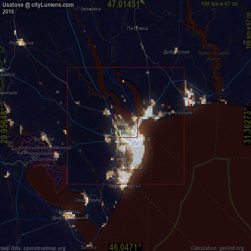
Analysis of Usatove night lights 2016
Square area 10x10 km:
 7.53%
7.53%90-99
10.09%80-89
5.11%70-79
4.97%60-69
6.53%50-59
12.5%40-49
12.22%30-39
9.52%20-29
15.48%10-19
14.35%0-9
1.7%Square area 50x50 km:
3.01%90-99
2.46%80-89
0.69%70-79
0.96%60-69
1.32%50-59
1.46%40-49
1.97%30-39
2.15%20-29
3.96%10-19
6.25%0-9
75.77%Clear (daylight) street map image can be seen on geolist.org.
Map coordinates:
47° 0' 52.2" North, 29° 57' 23.3" East
46° 31' 58.7" North, 30° 39' 34.6" East
46° 2' 49.6" North, 31° 21' 45.8" East
Some cities around Usatove sort by population:
• Odessa
8.3 km =5.2 mi,  137°
137°
• Chornomors’k
25.4 km =15.8 mi,  180°
180°
• Yuzhne
35.2 km =21.9 mi,  73°
73°
• Bilyayivka
34.3 km =21.3 mi,  260°
260°
• Ovidiopol
35.6 km =22.1 mi,  208°
208°
• Teplodar
25.8 km =16 mi, 263°
• Fontanka
15.7 km =9.8 mi,  76°
76°
• Mayaky
32.2 km =20 mi,  246°
246°
690648 (p: 7,732)
Sources (retrieved 2019-11-25):
» Earth at Night: Flat Maps 2012, 2016