Mayaky night lights from space
Night Light of Mayaky (Odesa) from space (Ukraine) Src. Average luminocity for 10x10km area is 4.9107% and for 50x50km: 2.7351%.
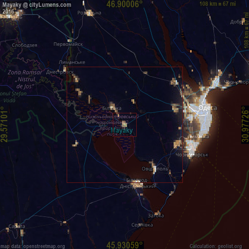
Analysis of Mayaky night lights 2016
Square area 10x10 km:
 0%
0%90-99
0%80-89
0%70-79
0.89%60-69
2.08%50-59
1.79%40-49
0.89%30-39
0%20-29
1.79%10-19
1.04%0-9
91.52%Square area 50x50 km:
0.05%90-99
0.22%80-89
0.15%70-79
0.28%60-69
0.59%50-59
0.6%40-49
0.69%30-39
0.4%20-29
0.78%10-19
1.96%0-9
94.28%Clear (daylight) street map image can be seen on geolist.org.
Map coordinates:
46° 54' 0.2" North, 29° 34' 15.6" East
46° 25' 2.9" North, 30° 16' 26.9" East
45° 55' 50.1" North, 30° 58' 38.1" East
Some cities around Mayaky sort by population:
• Chornomors’k
31.8 km =19.8 mi,  113°
113°
• Bilhorod-Dnistrovskyi
25.4 km =15.8 mi,  166°
166°
• Bilyayivka
8.5 km =5.3 mi,  328°
328°
• Ovidiopol
22.6 km =14 mi,  145°
145°
• Teplodar
10.6 km =6.6 mi,  21°
21°
• Usatove
32.2 km =20 mi,  66°
66°
• Shabo
32.8 km =20.4 mi,  164°
164°
• Starokozache
23.9 km =14.9 mi,  248°
248°
701561 (p: 5,937)
Sources (retrieved 2019-11-25):
» Earth at Night: Flat Maps 2012, 2016