Fontanka night lights from space
Night Light of Fontanka (Odesa) from space (Ukraine) Src. Average luminocity for 10x10km area is 17.8011% and for 50x50km: 12.6781%.
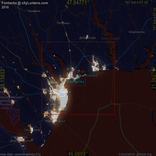
Analysis of Fontanka night lights 2016
Square area 10x10 km:
 2.98%
2.98%90-99
2.41%80-89
0.85%70-79
1.14%60-69
2.27%50-59
1.42%40-49
4.26%30-39
4.55%20-29
4.69%10-19
18.61%0-9
56.82%Square area 50x50 km:
3.03%90-99
2.51%80-89
0.69%70-79
1.03%60-69
1.3%50-59
1.46%40-49
2.16%30-39
2.15%20-29
3.69%10-19
7.05%0-9
74.94%Clear (daylight) street map image can be seen on geolist.org.
Map coordinates:
47° 2' 51.8" North, 30° 9' 23.5" East
46° 33' 59.3" North, 30° 51' 34.7" East
46° 4' 51.2" North, 31° 33' 46" East
Some cities around Fontanka sort by population:
• Odessa
13.9 km =8.6 mi,  224°
224°
• Chornomors’k
33 km =20.5 mi,  208°
208°
• Yuzhne
19.5 km =12.1 mi,  71°
71°
• Bilyayivka
50 km =31.1 mi,  259°
259°
• Ovidiopol
47.6 km =29.6 mi, 222°
• Teplodar
41.4 km =25.7 mi, 260°
• Usatove
15.7 km =9.8 mi, 256°
• Mayaky
47.8 km =29.7 mi,  249°
249°
709114 (p: 6,027)
Sources (retrieved 2019-11-25):
» Earth at Night: Flat Maps 2012, 2016