Ternopil night lights from space
Night Light of Ternopil from space (Ukraine) Src. Average luminocity for 10x10km area is 41.7731% and for 50x50km: 2.0989%.
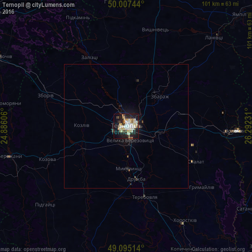

Analysis of Ternopil night lights 2016
Square area 10x10 km:
 4.9%
4.9%90-99
13.17%80-89
6.58%70-79
4.06%60-69
5.04%50-59
3.22%40-49
3.92%30-39
3.78%20-29
12.18%10-19
28.71%0-9
14.43%Square area 50x50 km:
0.2%90-99
0.53%80-89
0.26%70-79
0.16%60-69
0.24%50-59
0.19%40-49
0.2%30-39
0.24%20-29
0.61%10-19
2%0-9
95.36%Clear (daylight) street map image can be seen on geolist.org.
Map coordinates:
50° 0' 26.8" North, 24° 53' 9.8" East
49° 33' 12.3" North, 25° 35' 21" East
49° 5' 42.5" North, 26° 17' 32.3" East
Some cities around Ternopil sort by population:
• Бережани
48.7 km =30.3 mi,  256°
256°
• Terebovlya
29.3 km =18.2 mi,  162°
162°
• Zbarazh
18.2 km =11.3 mi,  47°
47°
• Kozova
34.3 km =21.3 mi,  247°
247°
• Lanivtsi
49.9 km =31 mi, 46°
• Pochaiv
50.5 km =31.4 mi,  353°
353°
• Zboriv
34.6 km =21.5 mi,  290°
290°
• Khorostkiv
45 km =28 mi,  147°
147°
691650 (p: 235,676)
Sources (retrieved 2019-11-25):
» NASA, Earths city lights 1995
» NASA city lights 2003
» Earth at Night: Flat Maps 2012, 2016