Starokostiantyniv night lights from space
Night Light of Starokostiantyniv (Khmelnytskyi) from space (Ukraine) Src. Average luminocity for 10x10km area is 0.2313% and for 50x50km: 0.0985%.
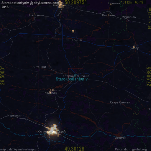
Analysis of Starokostiantyniv night lights 2016
Square area 10x10 km:
 0%
0%90-99
0%80-89
0%70-79
0%60-69
0%50-59
0%40-49
0%30-39
0%20-29
0.27%10-19
0.8%0-9
98.93%Square area 50x50 km:
0%90-99
0%80-89
0%70-79
0%60-69
0.02%50-59
0.02%40-49
0.06%30-39
0.03%20-29
0.06%10-19
0.03%0-9
99.78%Clear (daylight) street map image can be seen on geolist.org.
Map coordinates:
50° 12' 35.1" North, 26° 30' 1.1" East
49° 45' 27.5" North, 27° 12' 12.3" East
49° 18' 4.6" North, 27° 54' 23.6" East
Some cities around Starokostiantyniv sort by population:
• Khmelnytskyi
40.2 km =25 mi,  201°
201°
• Shepetivka
48.6 km =30.2 mi,  348°
348°
• Polonne
46.3 km =28.8 mi,  28°
28°
• Krasyliv
20.3 km =12.6 mi,  234°
234°
• Izyaslav
48.6 km =30.2 mi,  325°
325°
• Letychiv
51.8 km =32.2 mi,  143°
143°
• Poninka
53.1 km =33 mi, 26°
• Stara Syniava
34.5 km =21.4 mi,  119°
119°
692818 (p: 33,897)
Sources (retrieved 2019-11-25):
» Earth at Night: Flat Maps 2012, 2016