Novi Sanzhary night lights from space
Night Light of Novi Sanzhary (Poltava) from space (Ukraine) Src. Average luminocity for 10x10km area is 0.0789% and for 50x50km: 0.8111%.
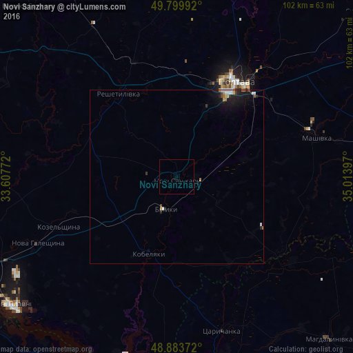
Analysis of Novi Sanzhary night lights 2016
Square area 10x10 km:
 0%
0%90-99
0%80-89
0%70-79
0%60-69
0%50-59
0%40-49
0%30-39
0%20-29
0%10-19
0.27%0-9
99.73%Square area 50x50 km:
0.11%90-99
0.14%80-89
0.08%70-79
0.06%60-69
0.12%50-59
0.01%40-49
0.09%30-39
0.11%20-29
0.26%10-19
1.01%0-9
98.03%Clear (daylight) street map image can be seen on geolist.org.
Map coordinates:
49° 47' 59.7" North, 33° 36' 27.8" East
49° 20' 38.2" North, 34° 18' 39" East
48° 53' 1.4" North, 35° 0' 50.3" East
Some cities around Novi Sanzhary sort by population:
• Poltava
32.4 km =20.1 mi,  30°
30°
• Horishni Plavni
61.5 km =38.2 mi,  232°
232°
• Karlivka
60.6 km =37.7 mi,  77°
77°
• Kobelyaky
23.2 km =14.4 mi,  200°
200°
• Reshetylivka
29.8 km =18.5 mi,  325°
325°
• Dykan’ka
55.7 km =34.6 mi,  16°
16°
• Tsarychanka
46.9 km =29.1 mi,  164°
164°
• Shyshaky
63.6 km =39.5 mi,  340°
340°
698927 (p: 8,020)
Sources (retrieved 2019-11-25):
» Earth at Night: Flat Maps 2012, 2016