Malynivka night lights from space
Night Light of Malynivka (Kharkiv) from space (Ukraine) Src. Average luminocity for 10x10km area is 1.7741% and for 50x50km: 0.8037%.
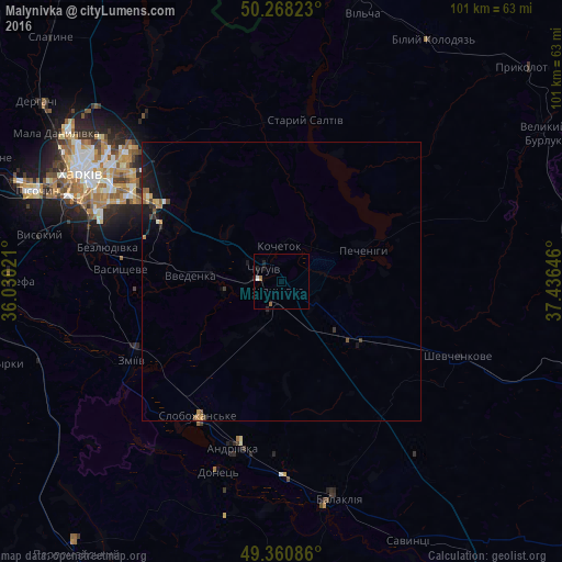
Analysis of Malynivka night lights 2016
Square area 10x10 km:
 0.4%
0.4%90-99
0.13%80-89
0%70-79
0%60-69
0.4%50-59
0.67%40-49
0%30-39
0%20-29
0.94%10-19
1.47%0-9
95.99%Square area 50x50 km:
0.03%90-99
0.07%80-89
0.05%70-79
0.13%60-69
0.14%50-59
0.18%40-49
0.07%30-39
0.13%20-29
0.21%10-19
0.96%0-9
98.03%Clear (daylight) street map image can be seen on geolist.org.
Map coordinates:
50° 16' 5.6" North, 36° 1' 48.8" East
49° 49' 0" North, 36° 43' 60" East
49° 21' 39.1" North, 37° 26' 11.3" East
Some cities around Malynivka sort by population:
• Kharkiv
39 km =24.2 mi,  297°
297°
• Chuhuyiv
3.9 km =2.4 mi, 303°
• Zmiyiv
31.9 km =19.8 mi,  240°
240°
• Slobozhans’ke
28.6 km =17.8 mi,  211°
211°
• Bezlyudivka
34.2 km =21.3 mi,  281°
281°
• Shevchenkove
34.4 km =21.4 mi,  113°
113°
• Vasyshcheve
29.2 km =18.1 mi,  272°
272°
• Eskhar
10.5 km =6.5 mi,  257°
257°
793657 (p: 7,502)
Sources (retrieved 2019-11-25):
» Earth at Night: Flat Maps 2012, 2016