Vasyshcheve night lights from space
Night Light of Vasyshcheve (Kharkiv) from space (Ukraine) Src. Average luminocity for 10x10km area is 0.7727% and for 50x50km: 7.8835%.
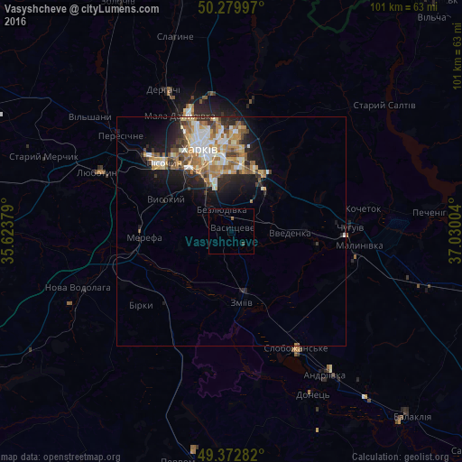
Analysis of Vasyshcheve night lights 2016
Square area 10x10 km:
 0%
0%90-99
0%80-89
0%70-79
0%60-69
0%50-59
0.53%40-49
0.53%30-39
0%20-29
0%10-19
0%0-9
98.93%Square area 50x50 km:
1.11%90-99
1.53%80-89
0.89%70-79
1.3%60-69
1.51%50-59
1.05%40-49
0.88%30-39
0.86%20-29
1.84%10-19
4.12%0-9
84.93%Clear (daylight) street map image can be seen on geolist.org.
Map coordinates:
50° 16' 47.9" North, 35° 37' 25.6" East
49° 49' 42.7" North, 36° 19' 36.9" East
49° 22' 22.2" North, 37° 1' 48.1" East
Some cities around Vasyshcheve sort by population:
• Kharkiv
17.7 km =11 mi,  342°
342°
• Merefa
19.8 km =12.3 mi,  268°
268°
• Zmiyiv
17.2 km =10.7 mi,  175°
175°
• Vysokyy
16.3 km =10.1 mi,  295°
295°
• Pokotylivka
14.4 km =8.9 mi,  310°
310°
• Bezlyudivka
6.8 km =4.2 mi,  319°
319°
• Pivdenne
19.5 km =12.1 mi,  288°
288°
• Eskhar
19.3 km =12 mi,  100°
100°
690335 (p: 5,862)
Sources (retrieved 2019-11-25):
» Earth at Night: Flat Maps 2012, 2016