Bezlyudivka night lights from space
Night Light of Bezlyudivka (Kharkiv) from space (Ukraine) Src. Average luminocity for 10x10km area is 6.8102% and for 50x50km: 8.5829%.
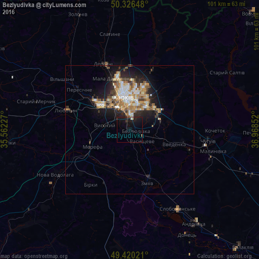
Analysis of Bezlyudivka night lights 2016
Square area 10x10 km:
 0.4%
0.4%90-99
0.4%80-89
0.8%70-79
0%60-69
0.27%50-59
0.8%40-49
0%30-39
1.34%20-29
2.01%10-19
17.51%0-9
76.47%Square area 50x50 km:
1.15%90-99
1.55%80-89
0.94%70-79
1.34%60-69
1.59%50-59
1.16%40-49
0.98%30-39
0.98%20-29
2.35%10-19
5.32%0-9
82.66%Clear (daylight) street map image can be seen on geolist.org.
Map coordinates:
50° 19' 35.3" North, 35° 33' 44.2" East
49° 52' 31.7" North, 36° 15' 55.4" East
49° 25' 12.8" North, 36° 58' 6.7" East
Some cities around Bezlyudivka sort by population:
• Kharkiv
11.7 km =7.3 mi,  355°
355°
• Merefa
16.5 km =10.3 mi,  249°
249°
• Solonytsivka
21.3 km =13.2 mi,  309°
309°
• Vysokyy
10.4 km =6.5 mi,  279°
279°
• Pokotylivka
7.7 km =4.8 mi,  303°
303°
• Pivdenne
14.2 km =8.8 mi,  273°
273°
• Budy
17.6 km =10.9 mi, 275°
• Vasyshcheve
6.8 km =4.2 mi,  139°
139°
712200 (p: 9,294)
Sources (retrieved 2019-11-25):
» Earth at Night: Flat Maps 2012, 2016