Hlevakha night lights from space
Night Light of Hlevakha (Kyiv) from space (Ukraine) Src. Average luminocity for 10x10km area is 14.988% and for 50x50km: 19.8198%.
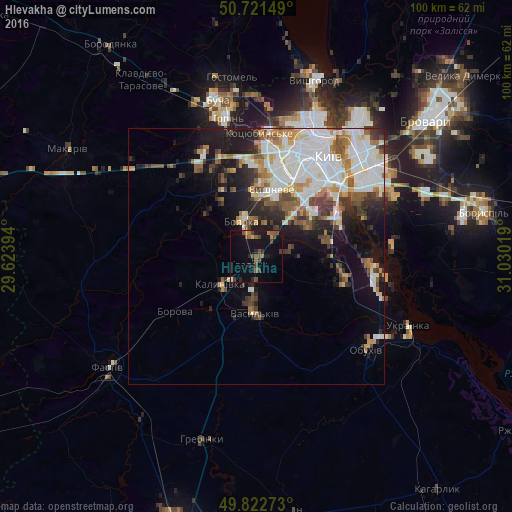
Analysis of Hlevakha night lights 2016
Square area 10x10 km:
 0.27%
0.27%90-99
0.27%80-89
0.53%70-79
0.8%60-69
2.94%50-59
4.81%40-49
4.95%30-39
2.01%20-29
2.67%10-19
18.45%0-9
62.3%Square area 50x50 km:
5.74%90-99
4.31%80-89
1.43%70-79
1.97%60-69
2.12%50-59
2.31%40-49
2.28%30-39
2.43%20-29
3.4%10-19
7.78%0-9
66.21%Clear (daylight) street map image can be seen on geolist.org.
Map coordinates:
50° 43' 17.4" North, 29° 37' 26.2" East
50° 16' 27.2" North, 30° 19' 37.4" East
49° 49' 21.8" North, 31° 1' 48.7" East
Some cities around Hlevakha sort by population:
• Kyiv
24.4 km =15.2 mi,  34°
34°
• Vasylkiv
9.8 km =6.1 mi,  185°
185°
• Boyarka
5.4 km =3.4 mi,  337°
337°
• Vyshneve
13.1 km =8.1 mi,  13°
13°
• Kotsyubyns’ke
23.8 km =14.8 mi,  0°
0°
• Chabany
10.1 km =6.3 mi,  42°
42°
• Borova
19.2 km =11.9 mi,  235°
235°
• Sofiyivska Borschagivka
15.4 km =9.6 mi, 10°
708784 (p: 8,835)
Sources (retrieved 2019-11-25):
» Earth at Night: Flat Maps 2012, 2016