Sofiyivska Borschagivka night lights from space
Night Light of Sofiyivska Borschagivka (Kyiv) from space (Ukraine) Src. Average luminocity for 10x10km area is 73.8669% and for 50x50km: 26.4577%.
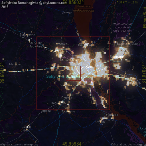
Analysis of Sofiyivska Borschagivka night lights 2016
Square area 10x10 km:
 22.13%
90-99
22.27%80-89
9.1%70-79
9.52%60-69
6.44%50-59
5.88%40-49
8.82%30-39
4.48%20-29
9.52%10-19
1.82%0-9
0%Square area 50x50 km:
6.88%90-99
5.43%80-89
2.02%70-79
2.64%60-69
2.73%50-59
2.96%40-49
3.22%30-39
3.95%20-29
6.35%10-19
13.42%0-9
50.41%Clear (daylight) street map image can be seen on geolist.org.
Map coordinates:
50° 51' 21.7" North, 29° 39' 50.8" East
50° 24' 36.2" North, 30° 22' 2.1" East
49° 57' 35.4" North, 31° 4' 13.3" East
Some cities around Sofiyivska Borschagivka sort by population:
• Kyiv
12.1 km =7.5 mi,  65°
65°
• Irpin
14.9 km =9.3 mi,  326°
326°
• Boyarka
11.3 km =7 mi,  206°
206°
• Vyshneve
2.3 km =1.4 mi,  174°
174°
• Kotsyubyns’ke
9.1 km =5.7 mi,  342°
342°
• Hlevakha
15.4 km =9.6 mi,  190°
190°
• Chabany
8.7 km =5.4 mi,  152°
152°
• Horenka
16.6 km =10.3 mi,  351°
351°
8504651 (p: 6,571)
Sources (retrieved 2019-11-25):
» Earth at Night: Flat Maps 2012, 2016