Kotsyubyns’ke night lights from space
Night Light of Kotsyubyns’ke (Kyiv City) from space (Ukraine) Src. Average luminocity for 10x10km area is 42.0434% and for 50x50km: 23.7489%.
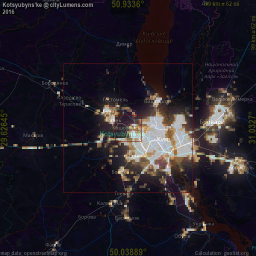
Analysis of Kotsyubyns’ke night lights 2016
Square area 10x10 km:
 6.16%
6.16%90-99
7.42%80-89
4.06%70-79
7.28%60-69
5.74%50-59
6.16%40-49
2.66%30-39
5.6%20-29
16.95%10-19
37.96%0-9
0%Square area 50x50 km:
6.63%90-99
5.03%80-89
1.72%70-79
2.23%60-69
2.4%50-59
2.74%40-49
2.76%30-39
3.37%20-29
5.4%10-19
11.46%0-9
56.25%Clear (daylight) street map image can be seen on geolist.org.
Map coordinates:
50° 56' 1" North, 29° 37' 35.2" East
50° 29' 18.1" North, 30° 19' 46.5" East
50° 2' 20" North, 31° 1' 57.7" East
Some cities around Kotsyubyns’ke sort by population:
• Kyiv
14.2 km =8.8 mi,  105°
105°
• Bucha
10.3 km =6.4 mi,  306°
306°
• Irpin
6.7 km =4.2 mi,  303°
303°
• Vyshneve
11.4 km =7.1 mi,  165°
165°
• Hostomel
10 km =6.2 mi,  332°
332°
• Vorzel’
13.9 km =8.6 mi, 296°
• Sofiyivska Borschagivka
9.1 km =5.7 mi,  162°
162°
• Horenka
7.7 km =4.8 mi,  1°
1°
704670 (p: 13,934)
Sources (retrieved 2019-11-25):
» Earth at Night: Flat Maps 2012, 2016