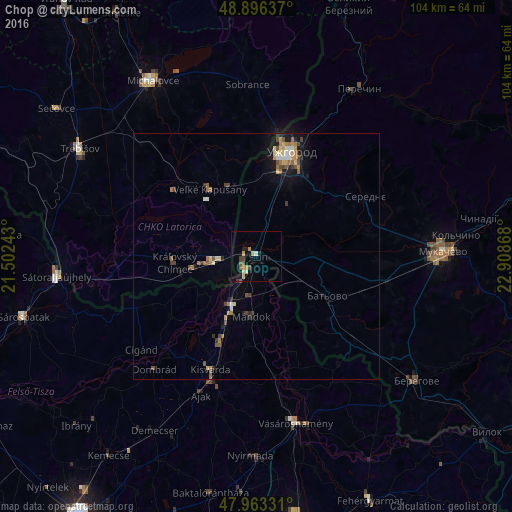
Chop night lights from space
Night Light of Chop (Transcarpathia) from space (Ukraine) Src. Average luminocity for 10x10km area is 8.5071% and for 50x50km: 2.5875%.
Analysis of Chop night lights 2016
Square area 10x10 km:
 0.28%
0.28%90-99
0.57%80-89
1.42%70-79
2.41%60-69
0.71%50-59
1.56%40-49
0.85%30-39
1.28%20-29
0.85%10-19
3.13%0-9
86.93%Square area 50x50 km:
0.18%90-99
0.2%80-89
0.43%70-79
0.35%60-69
0.48%50-59
0.49%40-49
0.41%30-39
0.36%20-29
0.27%10-19
1.5%0-9
95.35%Clear (daylight) street map image can be seen on geolist.org.
Map coordinates:
48° 53' 46.9" North, 21° 30' 8.7" East
48° 25' 55.1" North, 22° 12' 20" East
47° 57' 47.9" North, 22° 54' 31.2" East
Some cities around Chop sort by population:
• Uzhgorod
21.7 km =13.5 mi,  18°
18°
• Mukacheve
37.8 km =23.5 mi,  88°
88°
• Berehove
41.1 km =25.5 mi,  127°
127°
• Kisvárda, HU
25.6 km =15.9 mi,  200°
200°
• Sátoraljaújhely, HU
40.6 km =25.2 mi,  264°
264°
• Vásárosnamény, HU
35 km =21.7 mi,  166°
166°
• Perechyn
39.5 km =24.5 mi,  31°
31°
• Sobrance, SK
34.8 km =21.6 mi,  357°
357°
710409 (p: 8,587)
Sources (retrieved 2019-11-25):
» Earth at Night: Flat Maps 2012, 2016