Ulenje night lights from space
Night Light of Ulenje (Mbeya) from space (Tanzania) Src. Average luminocity for 10x10km area is 0% and for 50x50km: 1.9747%.
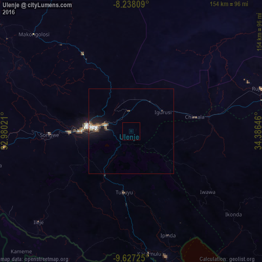
Analysis of Ulenje night lights 2016
Square area 10x10 km:
100  0%
0%
90-99 0%
80-89 0%
70-79 0%
60-69 0%
50-59 0%
40-49 0%
30-39 0%
20-29 0%
10-19 0%
0-9 100%
0%90-99
0%80-89
0%70-79
0%60-69
0%50-59
0%40-49
0%30-39
0%20-29
0%10-19
0%0-9
100%Square area 50x50 km:
100 0.22%
90-99 0.31%
80-89 0.16%
70-79 0.17%
60-69 0.31%
50-59 0.31%
40-49 0.48%
30-39 0.14%
20-29 0.33%
10-19 2.01%
0-9 95.54%
0.22%90-99
0.31%80-89
0.16%70-79
0.17%60-69
0.31%50-59
0.31%40-49
0.48%30-39
0.14%20-29
0.33%10-19
2.01%0-9
95.54%Clear (daylight) street map image can be seen on geolist.org.
Map coordinates:
8° 14' 17.1" South, 32° 58' 48.8" East
8° 55' 60" South, 33° 40' 60" East
9° 37' 38.1" South, 34° 23' 11.3" East
Some cities around Ulenje sort by population:
• Mbeya
25.9 km =16.1 mi,  278°
278°
• Katumba
34.2 km =21.3 mi,  192°
192°
• Tukuyu
35.4 km =22 mi, 185°
• Igurusi
20.5 km =12.7 mi,  63°
63°
• Chimala
38.4 km =23.9 mi,  77°
77°
• Kiwira
30.9 km =19.2 mi,  210°
210°
• Matamba
31.6 km =19.6 mi,  100°
100°
• Kandete
27.3 km =17 mi,  151°
151°
149239 (p: 12,219)
Sources (retrieved 2019-11-25):
» Earth at Night: Flat Maps 2012, 2016