Kisarawe night lights from space
Night Light of Kisarawe (Pwani) from space (Tanzania) Src. Average luminocity for 10x10km area is 8.9177% and for 50x50km: 24.7465%.
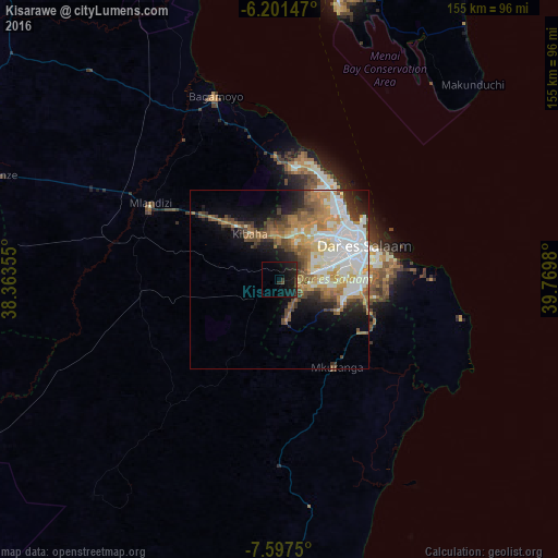
Analysis of Kisarawe night lights 2016
Square area 10x10 km:
 0%
0%90-99
0%80-89
0%70-79
0%60-69
0%50-59
0%40-49
3.46%30-39
2.38%20-29
8.01%10-19
22.08%0-9
64.07%Square area 50x50 km:
5.35%90-99
5.95%80-89
2.08%70-79
3.9%60-69
3.98%50-59
3.06%40-49
3.67%30-39
2.23%20-29
3.37%10-19
6.91%0-9
59.49%Clear (daylight) street map image can be seen on geolist.org.
Map coordinates:
6° 12' 5.3" South, 38° 21' 48.8" East
6° 54' 0" South, 39° 4' 0" East
7° 35' 51" South, 39° 46' 11.3" East
Some cities around Kisarawe sort by population:
• Dar es Salaam
24 km =14.9 mi,  69°
69°
• Bagamoyo
54 km =33.6 mi,  340°
340°
• Mlandizi
43 km =26.7 mi,  301°
301°
• Mkuranga
28.8 km =17.9 mi,  147°
147°
• Kibaha
22.2 km =13.8 mi,  311°
311°
• Vikindu
28.2 km =17.5 mi,  114°
114°
• Magomeni
23.1 km =14.4 mi,  61°
61°
• Maneromango
45.5 km =28.3 mi,  223°
223°
156996 (p: 12,507)
Sources (retrieved 2019-11-25):
» Earth at Night: Flat Maps 2012, 2016